| Mesoscale Discussion 1146 | |
| < Previous MD | |

|
|
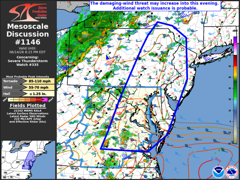
Mesoscale Discussion 1146 NWS Storm Prediction Center Norman OK 0522 PM CDT Sun Jun 14 2026 Areas affected...Parts of the Mid Atlantic Concerning...Severe Thunderstorm Watch 335... Valid 142222Z - 150015Z The severe weather threat for Severe Thunderstorm Watch 335 continues. SUMMARY...The damaging-wind threat may increase into this evening. Additional watch issuance is probable. DISCUSSION...Widely scattered strong storms are ongoing early this evening from south-central VA into western MD and eastern PA. Moderate buoyancy resides across parts of VA/MD, within a very warm/moist environment, while continued low-level moisture transport may allow for some additional destabilization with time into NJ and eastern PA. Effective shear of 30-40 kt will continue to support potential for organized convection, and an increase in storm coverage is expected as a midlevel shortwave trough approaches the region from the Ohio Valley. Ongoing semi-discrete convection will pose a threat of damaging wind and perhaps marginal hail, and a brief tornado cannot be ruled out. The anticipated increase in storm coverage could lead to modest upscale growth and one or more localized swaths of damaging wind through the evening. Additional watch issuance is probable to the northeast of WW 335 in response to these threats. ..Dean/Gleason.. 06/14/2026 ...Please see www.spc.noaa.gov for graphic product... ATTN...WFO...OKX...PHI...BGM...AKQ...CTP...LWX...RNK... LAT...LON 41637443 40007441 37837547 37177643 37267874 37967839 39237784 41247674 41727642 42257591 42117514 41637443 MOST PROBABLE PEAK TORNADO INTENSITY...85-110 MPH MOST PROBABLE PEAK WIND GUST...55-70 MPH MOST PROBABLE PEAK HAIL SIZE...UP TO 1.25 IN |
|
|
Top/All Mesoscale Discussions/Forecast Products/Home |
|
Source link