| Mesoscale Discussion 1145 | |
| < Previous MD | |

|
|
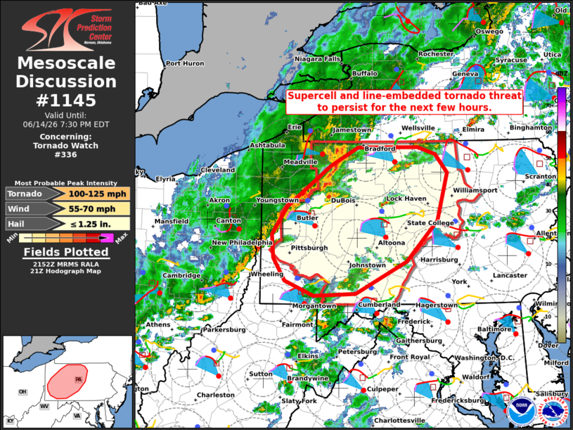
Mesoscale Discussion 1145 NWS Storm Prediction Center Norman OK 0454 PM CDT Sun Jun 14 2026 Areas affected...Parts of western and central Pennsylvania Concerning...Tornado Watch 336... Valid 142154Z - 142330Z The severe weather threat for Tornado Watch 336 continues. SUMMARY...Supercell tornado risk will persist for another few hours. A couple tornadoes and damaging winds are also possible with the approaching squall line from the west. DISCUSSION...The latest radar data from CCX shows a few discrete supercells evolving across western and central PA ahead of a cold front and related squall line. The CCX VWP is sampling a 30-40 kt low-level jet, which is yielding a clockwise-curved low-level hodograph with ample streamwise vorticity for RM supercells (320 m2/s2 0-1km SRH). This wind profile coupled with a warm/moist PBL (middle/upper 60s dewpoints) will continue to support a few discrete supercell structures capable of producing a couple of tornadoes. The supercell tornado risk will generally be maximized for the next few hours (through around 01Z), before the core of the low-level jet translates northward. Embedded tornadoes and damaging wind gusts will also be possible with the northeast/southwest-oriented squall line as it advances eastward across western/central PA, given the aforementioned favorable downstream environment. ..Weinman.. 06/14/2026 ...Please see www.spc.noaa.gov for graphic product... ATTN...WFO...CTP...PBZ... LAT...LON 39867878 39847954 40058008 40378029 40708032 41088004 41667923 41917873 41927762 41817729 41567708 40897727 40317783 39867878 MOST PROBABLE PEAK TORNADO INTENSITY...100-125 MPH MOST PROBABLE PEAK WIND GUST...55-70 MPH MOST PROBABLE PEAK HAIL SIZE...UP TO 1.25 IN |
|
|
Top/All Mesoscale Discussions/Forecast Products/Home |
|
Source link