| Mesoscale Discussion 1144 | |
| < Previous MD | |

|
|
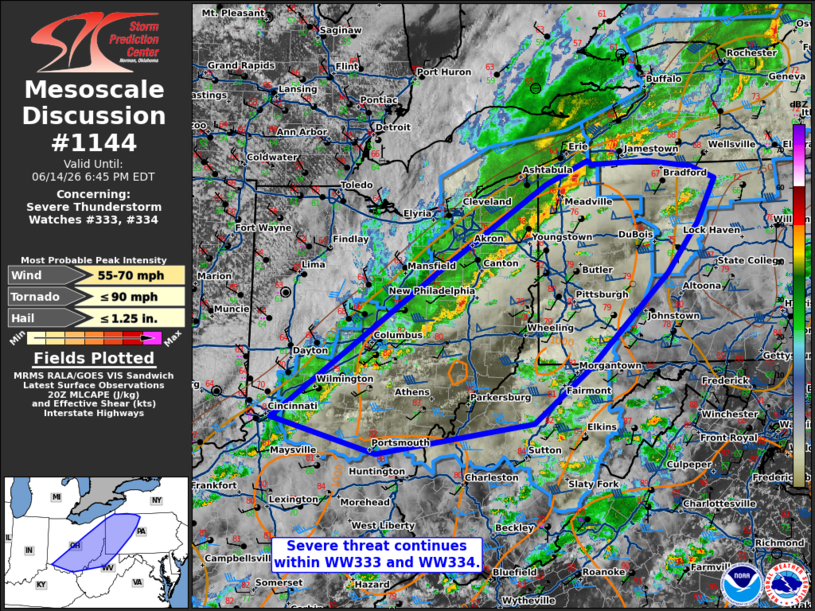
Mesoscale Discussion 1144 NWS Storm Prediction Center Norman OK 0352 PM CDT Sun Jun 14 2026 Areas affected...eastern Ohio...western Pennsylvania...western West Virginia Concerning...Severe Thunderstorm Watch 333...334... Valid 142052Z - 142245Z The severe weather threat for Severe Thunderstorm Watch 333, 334 continues. SUMMARY...Severe threat continues within WW333 and WW334. DISCUSSION...A line of thunderstorms continues eastward along the cold front into portions of eastern Ohio into western Pennsylvania and southwestern New York this afternoon. Recent reports with this line have included gusts 50-60 mph and a brief tornado in Crawford County Pennsylvania. Just ahead of the approaching line, a favorably unstable air mass is noted in SPC Mesoanalysis, and observed by the 18z RAOB from PIT. As this line continues eastward, potential for damaging winds will continue. Potential for a few isolated line embedded circulations will be greatest across portions of western PA where surface flow is remaining more southeasterly, enhancing low-level SRH. A few storms have developed ahead of the main line, which may warrant local extension of WW333 and WW334. ..Thornton.. 06/14/2026 ...Please see www.spc.noaa.gov for graphic product... ATTN...WFO...BUF...CTP...PBZ...RLX...CLE...ILN... LAT...LON 39088445 40768203 41768039 42047977 42007969 42027884 41967820 41827783 41327811 40757857 39677974 39048057 38688291 39088445 MOST PROBABLE PEAK TORNADO INTENSITY...UP TO 90 MPH MOST PROBABLE PEAK WIND GUST...55-70 MPH MOST PROBABLE PEAK HAIL SIZE...UP TO 1.25 IN |
|
|
Top/All Mesoscale Discussions/Forecast Products/Home |
|
Source link