| Mesoscale Discussion 1140 | |
| < Previous MD | |

|
|
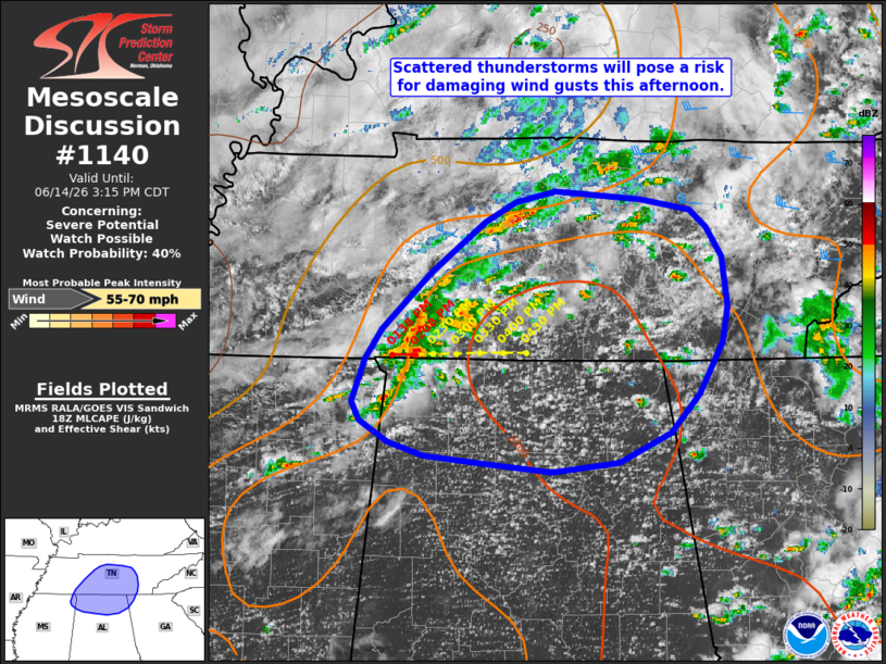
   Mesoscale Discussion 1140
   NWS Storm Prediction Center Norman OK
   0143 PM CDT Sun Jun 14 2026

   Areas affected...portions of the mid-Tennessee River Valley

   Concerning...Severe potential...Watch possible

   Valid 141843Z - 142015Z

   Probability of Watch Issuance...40 percent

   SUMMARY...Scattered thunderstorms will pose a risk for damaging wind
   gusts this afternoon across portions of the mid-Tennessee River
   Valley

   DISCUSSION...An uptick in convective coverage has been noted across
   portions of the mid-Tennessee River Valley over the past 30-60
   minutes with a broken broken band of developing thunderstorms noted
   per regional radar imagery. This activity is occurring along a
   remnant outflow boundary from overnight convection immediately
   downstream of a subtle mid-level MCV. Modestly enhanced mid-level
   westerly flow (30+ kts sampled above 1.5-2 km AGL by the HTX VWP and
   40+ kts sampled by OHX) is contributing to 20-30 kts of effective
   shear. Coupled with a moderately unstable environment in place ahead
   of these storms, some potential exists for a marginally more
   organized multicell cluster/band to evolve eastward this afternoon,
   with an attendant risk for damaging wind gusts. Watch issuance
   remains uncertain at this time, but a targeted Severe Thunderstorm
   Watch may be considered should a corridor of greater severe
   potential become evident.

   ..Chalmers/Mosier.. 06/14/2026

   ...Please see www.spc.noaa.gov for graphic product...

   ATTN...WFO...MRX...FFC...OHX...BMX...HUN...MEG...

   LAT...LON   34168659 34228728 34288776 34378807 34538834 34688840
               35008828 35218813 35648770 36028720 36168693 36258657
               36188580 36118535 35988519 35758506 35398500 35128505
               34738526 34448552 34228600 34168659

   MOST PROBABLE PEAK WIND GUST...55-70 MPH
|
|
|
Top/All Mesoscale Discussions/Forecast Products/Home |
|
Source link