| Mesoscale Discussion 1131 | |
| < Previous MD Next MD > | |

|
|
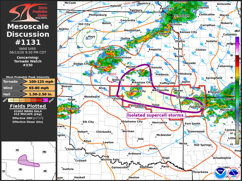
Mesoscale Discussion 1131 NWS Storm Prediction Center Norman OK 0802 PM CDT Sat Jun 13 2026 Areas affected...ENortheast Oklahoma...Southeast Kansas...Northwest Arkansas Concerning...Tornado Watch 330... Valid 140102Z - 140230Z The severe weather threat for Tornado Watch 330 continues. SUMMARY...Isolated supercell storms will persist this evening, while more widespread severe threat approaches from the northwest. DISCUSSION...Recent radar imagery shows three large supercell storms affecting the region. One is in Kay county OK, one in Benton County AR, and one in Butler county KS. All three storms have a history of large hail. The KS storm has begun to weaken at it tracks away from the outflow boundary, while the other two cells remain anchored near the boundary and in a favorable CAPE/shear parameter space for occasional large hail and damaging winds. The low-level jet will begin strengthening soon, which could also maintain/raise the risk of a tornado or two. A cluster of thunderstorms to the west of Wichita is also approaching this region, and is likely to congeal into a bowing line segment during the next 1-2 hours. This would increase the risk of damaging winds through 04z. However, there is uncertainty regarding how the westward-surging outflow from the Kay county supercell will affect this scenario. ..Hart.. 06/14/2026 ...Please see www.spc.noaa.gov for graphic product... ATTN...WFO...SGF...TSA...ICT...OUN... LAT...LON 37489734 37849618 36849576 36369368 35959358 35989456 36429740 36919764 37489734 MOST PROBABLE PEAK TORNADO INTENSITY...100-125 MPH MOST PROBABLE PEAK WIND GUST...65-80 MPH MOST PROBABLE PEAK HAIL SIZE...1.50-2.50 IN |
|
|
Top/All Mesoscale Discussions/Forecast Products/Home |
|
Source link