| Mesoscale Discussion 1130 | |
| < Previous MD | |

|
|
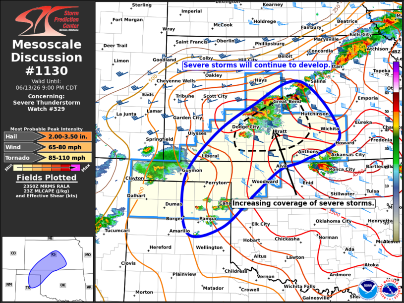
Mesoscale Discussion 1130 NWS Storm Prediction Center Norman OK 0653 PM CDT Sat Jun 13 2026 Areas affected...Central Kansas...northwest Oklahoma...eastern Texas Panhandle Concerning...Severe Thunderstorm Watch 329... Valid 132353Z - 140200Z The severe weather threat for Severe Thunderstorm Watch 329 continues. SUMMARY...Severe thunderstorms will continue to increase in coverage this evening from central KS into the TX Panhandle. Large hail will be the main threat initially, but damaging wind potential will increase by mid-evening. DISCUSSION...A cluster of intense thunderstorms has developed in the past hour along the cold front between Dodge City and Great Bend. These storms are tracking southeastward into a reservoir of very warm/moist and unstable air, with upscale organization into a linear MCS likely in the next couple of hours. As this occurs, the risk of rather widespread damaging winds will also rise. It is unclear how the isolated severe storms south of Wichita will affect the bowing line as it tracks southeastward in the next few hours. Other more isolated but intense storms have formed in the eastern TX Panhandle. This activity will slowly develop eastward into northwest OK this evening with a risk of damaging wind gusts and hail. ..Hart.. 06/13/2026 ...Please see www.spc.noaa.gov for graphic product... ATTN...WFO...ICT...OUN...DDC...AMA... LAT...LON 36540140 37570058 38319940 38929789 37629671 37029778 36809851 36239927 35410025 35250127 36540140 MOST PROBABLE PEAK TORNADO INTENSITY...85-110 MPH MOST PROBABLE PEAK WIND GUST...65-80 MPH MOST PROBABLE PEAK HAIL SIZE...2.00-3.50 IN |
|
|
Top/All Mesoscale Discussions/Forecast Products/Home |
|
Source link