| Mesoscale Discussion 1129 | |
| < Previous MD | |

|
|
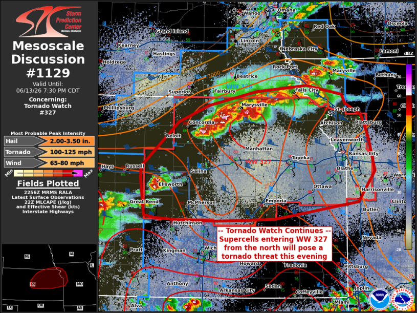
Mesoscale Discussion 1129 NWS Storm Prediction Center Norman OK 0558 PM CDT Sat Jun 13 2026 Areas affected...Northeastern Kansas Concerning...Tornado Watch 327... Valid 132258Z - 140030Z The severe weather threat for Tornado Watch 327 continues. SUMMARY...The threat for tornado watch 327 continues into the evening as thunderstorms advance southeastward from the KS/NE border. Supercells capable of tornadoes, damaging winds of 65-80 MPH, and 2-3.5 inch hail will all be possible. DISCUSSION...A cluster of supercell thunderstorms has developed along a cold front in the vicinity of the KS/NE border and is currently moving southeastward into WW 327. With deep-layer shear exceeding 45 kts and copious buoyancy ahead of these storms, the expectation is that both discrete and line-embedded supercells will pose a threat for all hazards over the next few hours. Additional modifications to the hodograph from the onset of the nocturnal low-level jet will will support an increase in tornado threat near and after sunset, particularly with any preexisting dominant/isolated supercell thunderstorms. The mixed supercellular/linear mode will also support large hail up to 3.5 inches and damaging straight-line winds up to 80 MPH. ..Halbert.. 06/13/2026 ...Please see www.spc.noaa.gov for graphic product... ATTN...WFO...EAX...OAX...TOP...ICT...GID...DDC... LAT...LON 38759854 38949855 39629783 39879725 40099632 40189536 40049468 39919462 39739431 39399418 38899405 38439438 38289535 38189597 38169659 38159710 38169780 38199826 38239847 38759854 MOST PROBABLE PEAK TORNADO INTENSITY...100-125 MPH MOST PROBABLE PEAK WIND GUST...65-80 MPH MOST PROBABLE PEAK HAIL SIZE...2.00-3.50 IN |
|
|
Top/All Mesoscale Discussions/Forecast Products/Home |
|
Source link