|
|
| Mesoscale Discussion 1128 | |
| < Previous MD Next MD > | |

|
|
   Mesoscale Discussion 1128
   NWS Storm Prediction Center Norman OK
   0228 PM CDT Sun Jun 02 2024

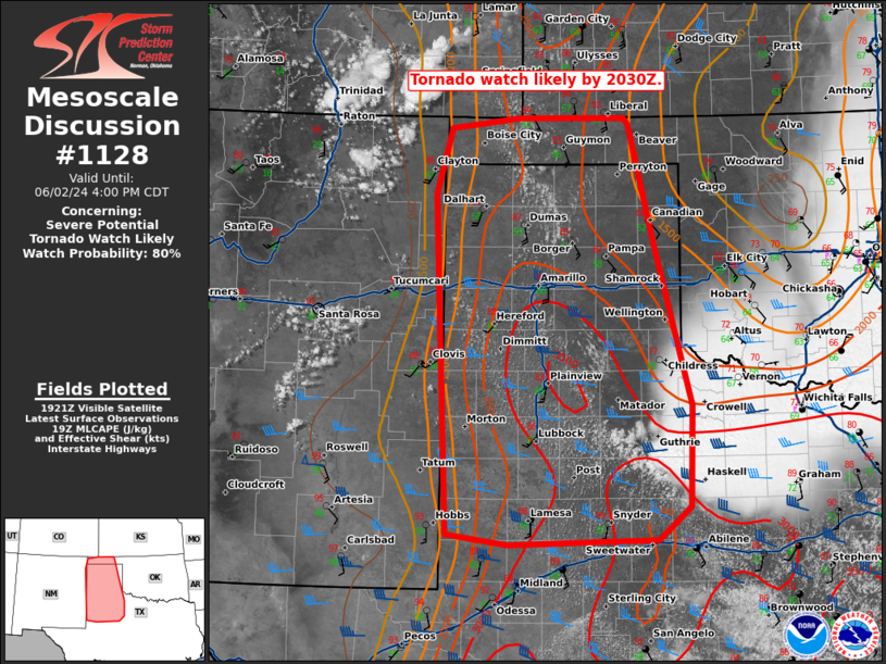
   Areas affected...The TX/OK Panhandles into West Texas

   Concerning...Severe potential...Tornado Watch likely

   Valid 021928Z - 022100Z

   Probability of Watch Issuance...80 percent

   SUMMARY...A tornado watch will likely be issued by 2030Z for the
   OK/TX Panhandles into portions of West Texas.

   DISCUSSION...An earlier outflow boundary has now stalled near
   Lubbock with an expanding cu field in the vicinity of the boundary.
   High-based cumulus has started to form across eastern New Mexico and
   southeast Colorado, indicating the increased ascent ahead of the
   approaching mid-level shortwave trough. In addition, the dryline has
   started to mix east and is now located near the TX/NM border. The
   combination of these factors indicate that robust thunderstorm
   development is likely in the next 1 to 2 hours. Effective shear
   around 35 knots and MLCAPE of 2000 to 3000 J/kg (per SPC
   mesoanalysis) will support supercells capable of hail up to baseball
   sized. Very high moisture content, the outflow boundary, and backed
   flow in the recovered outflow airmass all support some tornado
   threat with any well-established supercells. Therefore, a tornado
   watch will likely be needed by 2030Z.

   ..Bentley/Smith.. 06/02/2024

   ...Please see www.spc.noaa.gov for graphic product...

   ATTN...WFO...OUN...DDC...SJT...LUB...AMA...MAF...PUB...ABQ...

   LAT...LON   32520031 32510091 32460220 32580298 34380306 36180315
               36880295 36990206 36990071 36920066 35610032 33949986
               32879989 32520031
|
|
|
Top/All Mesoscale Discussions/Forecast Products/Home |
|


