| Mesoscale Discussion 1127 | |
| < Previous MD | |

|
|
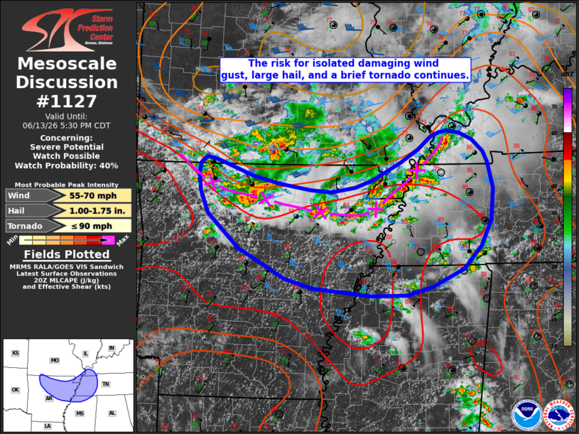
   Mesoscale Discussion 1127
   NWS Storm Prediction Center Norman OK
   0355 PM CDT Sat Jun 13 2026

   Areas affected...portions of northern Arkansas and the Mid-South

   Concerning...Severe potential...Watch possible

   Valid 132055Z - 132230Z

   Probability of Watch Issuance...40 percent

   SUMMARY...The threat for damaging wind gusts, large hail, and a
   brief tornado continues across portions of northern/eastern Arkansas
   and will soon spread into western Tennessee and perhaps northern
   Mississippi.

   DISCUSSION...Convective coverage has increased over the past 1-2
   hours along a remnant outflow boundary extending from far
   southwestern Missouri into northern Arkansas and toward the
   mid-Mississippi Valley. The predominant storm mode consists of a mix
   of multicell clusters and occasional supercell structures. MRMS MESH
   estimates have ranged up to 1.5" with some storms, with 1" hail
   previously reported in northern Arkansas. Latest objective analysis
   indicate this activity is approaching a relative maximum in
   available buoyancy along the Mississippi River which could result in
   some increase in the severe potential over the next 1-2 hours, with
   the main risks being large hail and damaging wind gusts.

   Some cells have also exhibited transient periods of enhanced
   low-level rotation. Low-level shear remains weak ahead of the
   remnant outflow boundary, with less than 50 m2/s2 0-1 km SRH sampled
   by the NQA VAD. Thus, any potential for a brief tornado is likely to
   be tied to any cell that can favorably interact with the outflow
   boundary. With greater effective shear remaining displaced to the
   north of the outflow boundary, uncertainty remains regarding storm
   longevity and the magnitude of the severe threat. Trends will
   continue to be monitored for potential watch issuance.

   ..Chalmers/Mosier.. 06/13/2026

   ...Please see www.spc.noaa.gov for graphic product...

   ATTN...WFO...PAH...MEG...LZK...SGF...TSA...

   LAT...LON   35239268 35769327 36099341 36369343 36519340 36599329
               36569310 36329243 36209195 36129138 36089101 36159056
               36269024 36538974 36728940 36918917 36988903 37008887
               36968865 36878841 36698821 36528814 36148803 35668807
               35288827 34948859 34688914 34548961 34539028 34659133
               34799185 35189260 35239268

   MOST PROBABLE PEAK TORNADO INTENSITY...UP TO 90 MPH
   MOST PROBABLE PEAK WIND GUST...55-70 MPH
   MOST PROBABLE PEAK HAIL SIZE...1.00-1.75 IN
|
|
|
Top/All Mesoscale Discussions/Forecast Products/Home |
|
Source link