| Mesoscale Discussion 1124 | |
| < Previous MD | |

|
|
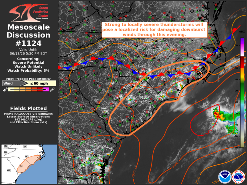
   Mesoscale Discussion 1124
   NWS Storm Prediction Center Norman OK
   0207 PM CDT Sat Jun 13 2026

   Areas affected...portions of the Southeast

   Concerning...Severe potential...Watch unlikely

   Valid 131907Z - 132130Z

   Probability of Watch Issuance...5 percent

   SUMMARY...Widely scattered thunderstorms will bring a localized risk
   for damaging downburst winds. Watch issuance is not anticipated.

   DISCUSSION...Latest surface observations depict a hot, humid air
   mass in place across the southeastern U.S., with temperatures in the
   mid-to-upper 90s F and dewpoints in the upper 60s noted along the
   Atlantic Coast. Surface convergence along the sea breeze and a of a
   roughly west-east oriented stationary boundary is supporting
   isolated thunderstorm development as of 19 UTC, with additional
   agitated cumulus noted on visible satellite imagery. As thunderstorm
   coverage expands through the afternoon (particularly where low-level
   convergence maximizes over northeastern SC and southeastern NC),
   steep low-level lapse rates and high PWAT contents (1.75-2.0") will
   favor the potential for isolated strong to locally damaging
   downburst winds. An instance or two of small hail may also accompany
   the most robust cores that develop along the sea breeze. A lack of
   greater effective shear will limit overall storm organization and
   longevity, thus precluding a greater severe risk. Given this, watch
   issuance is not anticipated.

   ..Chalmers/Mosier.. 06/13/2026

   ...Please see www.spc.noaa.gov for graphic product...

   ATTN...WFO...MHX...RAH...ILM...CHS...CAE...

   LAT...LON   33248117 33638083 34747966 34967935 35107901 35297836
               35377793 35437759 35457700 35437671 35377652 35287638
               35167632 34997638 34847652 34717672 34607693 34547720
               34427745 34267768 34027780 33857792 33797822 33777852
               33627874 33327902 33077923 32588000 32408028 32418062
               32498092 32678114 32908128 33248117

   MOST PROBABLE PEAK WIND GUST...UP TO 60 MPH
|
|
|
Top/All Mesoscale Discussions/Forecast Products/Home |
|
Source link