| Mesoscale Discussion 1123 | |
| < Previous MD | |

|
|
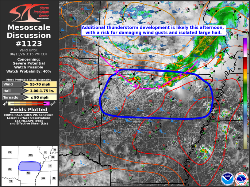
   Mesoscale Discussion 1123
   NWS Storm Prediction Center Norman OK
   0150 PM CDT Sat Jun 13 2026

   Areas affected...portions of northern/central Arkansas

   Concerning...Severe potential...Watch possible

   Valid 131850Z - 132015Z

   Probability of Watch Issuance...40 percent

   SUMMARY...Additional thunderstorm development is expected this
   afternoon across southern Missouri and northern Arkansas along a
   remnant outflow boundary, with a risk for damaging wind gusts and
   large hail.

   DISCUSSION...Latest surface analysis and visible satellite data
   depicts a remnant outflow boundary that has recently stalled across
   far southwest Missouri and northern Arkansas. Ahead/south of the
   outflow boundary, rich low-level moisture (dewpoints in the mid-70s
   F) is contributing to the development of strong buoyancy (around
   3000 J/kg MLCAPE). As continued insolation continues to erode
   remaining inhibition, convergence along the outflow boundary is
   likely to support additional strong to severe thunderstorm
   development this afternoon.

   A zone of modestly enhanced mid-level flow (sampled by the SGF VWP)
   downstream of an MCV analyzed over southeast Kansas and modest
   effective shear of 25-35 kts is likely to support some updraft
   organization, with initially discrete cells bringing an isolated
   threat for large hail before a quick transition to a multicell storm
   mode yields a greater threat for damaging winds. A brief tornado
   also cannot be ruled out with any cell that can favorably interact
   with the remnant outflow boundary. The displacement of greater
   effective shear to the north of the outflow boundary is largely
   expected to preclude greater storm organization. A Severe
   Thunderstorm Watch could be needed should a corridor of greater
   severe potential become evident, however.

   ..Chalmers/Mosier.. 06/13/2026

   ...Please see www.spc.noaa.gov for graphic product...

   ATTN...WFO...PAH...MEG...LZK...SGF...TSA...

   LAT...LON   36409414 36529394 36649374 36669337 36629196 36569108
               36489069 36319043 36149019 35749007 35339016 35159036
               35089075 35079118 35109186 35129295 35159375 35239427
               35359443 35559450 35749451 35999437 36409414

   MOST PROBABLE PEAK TORNADO INTENSITY...UP TO 90 MPH
   MOST PROBABLE PEAK WIND GUST...55-70 MPH
   MOST PROBABLE PEAK HAIL SIZE...1.00-1.75 IN
|
|
|
Top/All Mesoscale Discussions/Forecast Products/Home |
|
Source link