| Mesoscale Discussion 112 | |
| < Previous MD | |

|
|
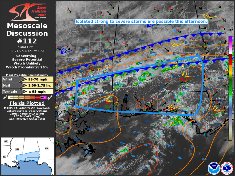
   Mesoscale Discussion 0112
   NWS Storm Prediction Center Norman OK
   0214 PM CST Sat Feb 21 2026

   Areas affected...Southern MS/AL into the FL Panhandle

   Concerning...Severe potential...Watch unlikely

   Valid 212014Z - 212245Z

   Probability of Watch Issuance...20 percent

   SUMMARY...Isolated strong to severe storms are possible this
   afternoon.

   DISCUSSION...Convection is gradually increasing in coverage early
   this afternoon from southeast MS into south AL, along and ahead of a
   southward-sagging cold front. Some recovery has occurred this
   afternoon to the north of the initial wind shift, with the leading
   edge of the deeper cold and stable air still across parts of central
   MS/AL, to the north of the developing storms.

   MLCAPE of 1000-1500 J/kg and strong deep-layer shear are
   conditionally favorable for organized storm structures, including
   supercells. However, aside from weakly confluent flow near the
   front, forcing for ascent is expected to remain generally
   weak/nebulous across the region through the afternoon. The modest
   ascent and a warm layer based around 700 mb (as observed on the 18Z
   LIX sounding) may result in only slow intensification of the
   developing storms and generally isolated severe coverage, though a
   couple splitting supercells and/or small bowing segments may evolve
   with time. If developing convection can mature and be sustained
   near/south of the front, then some threat for isolated hail and
   damaging winds could evolve this afternoon.

   ..Dean/Hart.. 02/21/2026

   ...Please see www.spc.noaa.gov for graphic product...

   ATTN...WFO...TAE...BMX...MOB...JAN...LIX...

   LAT...LON   30528527 30258543 30358727 30388854 30518978 31338973
               31828712 32138527 31888511 31648512 31168514 30528527

   MOST PROBABLE PEAK TORNADO INTENSITY...UP TO 95 MPH
   MOST PROBABLE PEAK WIND GUST...55-70 MPH
   MOST PROBABLE PEAK HAIL SIZE...1.00-1.75 IN
|
|
|
Top/All Mesoscale Discussions/Forecast Products/Home |
|
Source link