|
|
| Mesoscale Discussion 1114 | |
| < Previous MD Next MD > | |

|
|
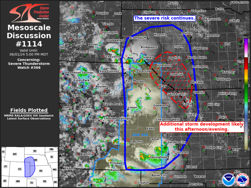
Mesoscale Discussion 1114 NWS Storm Prediction Center Norman OK 0454 PM CDT Sat Jun 01 2024 Areas affected...much of eastern CO...western KS...and parts of western NE Concerning...Severe Thunderstorm Watch 366... Valid 012154Z - 012300Z The severe weather threat for Severe Thunderstorm Watch 366 continues. SUMMARY...Ongoing clusters of severe storms should gradually mature and move east with a risk for hail and damaging winds. Additional storm development is possible farther east into parts of KS/NE. DISCUSSION...As of 2145 UTC, regional observations showed several widely scattered clusters of strong to severe storms ongoing from southern WY into eastern CO and far western KS. Hail and damaging winds have occurred with these storms, and that threat will likely continue this afternoon and into the evening given moderate buoyancy and effective shear in place. Additional storm development appears likely along the eastern fringes of WW366 later this afternoon into the evening from parts of northwest KS into southwestern NE. Deepening cumulus was noted along a modifying baroclinic zone from near GLD to OGA. Hi-res guidance and observation trends suggest a few more strong to severe storms are likely within this zone. Given the moderate buoyancy and bulk shear, organized storms capable of hail and damaging winds also appear likely. A tornado or two will also be possible given some enhanced low-level shear along the modified boundary. ..Lyons/Hart.. 06/01/2024 ...Please see www.spc.noaa.gov for graphic product... ATTN...WFO...LBF...DDC...GLD...PUB...BOU...CYS... LAT...LON 37000239 37000321 37020367 37280374 39400379 41150400 41910374 42350260 42420147 42210100 41660064 40920045 39150027 38560049 37540126 37100190 37000239 |
|
|
Top/All Mesoscale Discussions/Forecast Products/Home |
|


