| Mesoscale Discussion 1113 | |
| < Previous MD | |

|
|
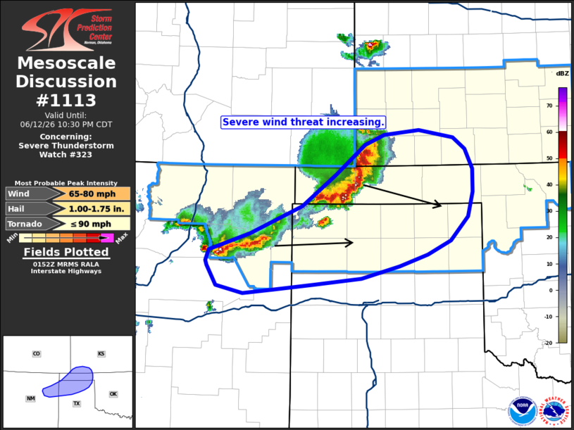
Mesoscale Discussion 1113 NWS Storm Prediction Center Norman OK 0855 PM CDT Fri Jun 12 2026 Areas affected...Northern Texas and Oklahoma Panhandles...far northeast New Mexico...far southwest Kansas Concerning...Severe Thunderstorm Watch 323... Valid 130155Z - 130330Z The severe weather threat for Severe Thunderstorm Watch 323 continues. SUMMARY...The potential for severe winds is increasing across far northeastern New Mexico into the northern Texas Panhandle and central Oklahoma Panhandle. DISCUSSION...Reflectivity and velocity data from KAMA shows the early stages of a consolidated outflow surge within a developing linear segment west of Guymon, OK. Further southwest, initially semi-discrete cells are also undergoing a linear transition as cold pools begin to amalgamate across far northeast New Mexico. Recent VWP observations from KAMA show the onset of the nocturnal jet is underway with winds in the 0-1 km layer increasing to 30-35 knots, which should act to increase low-level ascent on the southern flanks of the developing linear segments. Additionally, recent RAP mesoanalysis depicts a plume of steep low-level lapse rates between 8-9 C/km immediately downstream of this activity, which will help augment low-level downdraft accelerations and strengthen outflow winds. Consequently, a uptick in severe wind potential appears likely over the next 1-2 hours downstream across the northern TX Panhandle and the central OK Panhandle. ..Moore.. 06/13/2026 ...Please see www.spc.noaa.gov for graphic product... ATTN...WFO...DDC...AMA...PUB...ABQ... LAT...LON 35880436 36100370 36470288 36870233 37260186 37400156 37460100 37350044 37200025 36940013 36640013 36330021 36020049 35840086 35680131 35530192 35450269 35380335 35330382 35420425 35690439 35740442 35880436 MOST PROBABLE PEAK TORNADO INTENSITY...UP TO 90 MPH MOST PROBABLE PEAK WIND GUST...65-80 MPH MOST PROBABLE PEAK HAIL SIZE...1.00-1.75 IN |
|
|
Top/All Mesoscale Discussions/Forecast Products/Home |
|
Source link