|
|
| Mesoscale Discussion 1101 | |
| < Previous MD | |

|
|
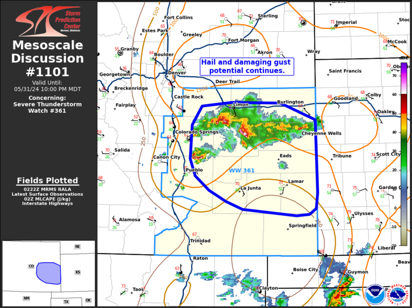
Mesoscale Discussion 1101 NWS Storm Prediction Center Norman OK 0924 PM CDT Fri May 31 2024 Areas affected...east-central and parts of southeastern Colorado Concerning...Severe Thunderstorm Watch 361... Valid 010224Z - 010400Z The severe weather threat for Severe Thunderstorm Watch 361 continues. SUMMARY...The ongoing cluster of severe storms will likely remain capable of damaging hail (some greater than 2 inches) and severe wind gusts into this evening. DISCUSSION...As of 0215 UTC, regional radar analysis showed a loose cluster of strong to severe storms ongoing across east-central CO. Over the last 2 hours, several reports of severe hail have occurred with these storms. Moderate instability and deep-layer shear remain in place ahead of the cluster suggesting a continued risk for strong updrafts capable of severe hail, some of which could be greater than 2 inches. Recent radar trends and surface observations also suggest stronger cold pool development is underway, which may eventually support the development of a small MCS. Along with the risk for hail, damaging wind potential may increase as storms begin to propagate east/southeast over the next few hours. However, with the onset of nocturnal cooling and air mass overturning from previous convection, it remains unclear how far south and east the severe threat will persist. ..Lyons.. 06/01/2024 ...Please see www.spc.noaa.gov for graphic product... ATTN...WFO...DDC...GLD...PUB...BOU... LAT...LON 37720206 37630219 37610244 37700347 37830380 38000412 38220440 38470449 38990446 39280428 39340370 39330274 39070205 37960203 37720206 |
|
|
Top/All Mesoscale Discussions/Forecast Products/Home |
|


