|
|
| Mesoscale Discussion 1100 | |
| < Previous MD Next MD > | |

|
|
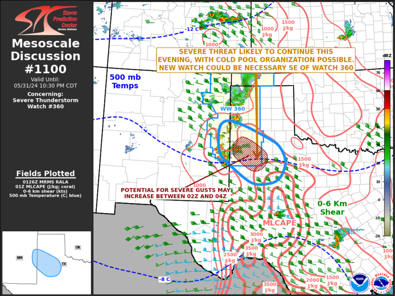
Mesoscale Discussion 1100 NWS Storm Prediction Center Norman OK 0828 PM CDT Fri May 31 2024 Areas affected...Eastern New Mexico...West Texas Concerning...Severe Thunderstorm Watch 360... Valid 010128Z - 010330Z The severe weather threat for Severe Thunderstorm Watch 360 continues. SUMMARY...A potential for severe wind gusts and isolated large hail will likely continue this evening, as a cluster or line of strong to severe thunderstorms moves southeastward across west Texas. New watch issuance may be needed to the southeast of WW 360 later this evening. DISCUSSION...The latest hi-resolution radar imagery from Amarillo and Lubbock shows a relatively large cluster of strong to severe storms currently straddling the New Mexico-Texas state-line. This cluster is expected to become more organized as it moves southeastward toward an axis of strong instability, currently located over the eastern part of the Caprock. The RAP is estimating MLCAPE within this corridor in the 2000 to 3000 J/kg range. In addition, RAP forecast soundings across west Texas have 0-6 km shear in the 35 to 40 knot range, with 700-500 mb lapse rates near 7.5 C/km. This environment should be favorable for isolated supercells capable of large hail. Although the cells are primarily discrete, some short-term solutions suggest that a transition to linear mode will be possible. If this were to happen, the wind-damage threat would likely increase, as the storms move southeastward into the stronger instability. ..Broyles.. 06/01/2024 ...Please see www.spc.noaa.gov for graphic product... ATTN...WFO...LUB...AMA...MAF...ABQ... LAT...LON 33310289 32720200 32690120 32850079 33190053 33630045 34170076 34510135 34980244 35140320 34840353 34150356 33730340 33310289 |
|
|
Top/All Mesoscale Discussions/Forecast Products/Home |
|


