| Mesoscale Discussion 110 | |
| < Previous MD | |

|
|
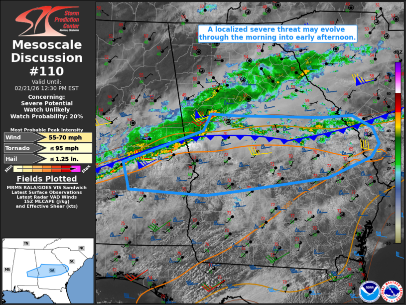
   Mesoscale Discussion 0110
   NWS Storm Prediction Center Norman OK
   0934 AM CST Sat Feb 21 2026

   Areas affected...Parts of southeast AL into central/southern GA and
   southern SC

   Concerning...Severe potential...Watch unlikely

   Valid 211534Z - 211730Z

   Probability of Watch Issuance...20 percent

   SUMMARY...Some uptick in the localized severe threat is possible
   through the morning into early afternoon.

   DISCUSSION...A small bowing segment with a history of producing
   localized wind damage is moving into west-central GA this morning,
   with other loosely organized convection trailing southwestward into
   south-central AL. This convection is generally moving along or just
   north of a sharp baroclinic zone draped from southern MS into
   central AL/GA and southern SC. Midlevel lapse rates are generally
   modest at best, but modest diurnal heating and MLCAPE approaching
   1000 J/kg (with a similar magnitude of MUCAPE immediately north of
   the front) should help to sustain deep convection through the
   morning.

   Area VWPs depict rather strong deep-layer shear and moderate
   southwesterly low-level flow, which will continue to be favorable
   for occasionally organized storm structures. However, with a
   tendency for the outflow-reinforced cold front to sag southward with
   time and potentially undercut the strongest convection, the
   organized severe threat may remain isolated through the morning.

   Locally damaging wind appears to be the most likely short-term
   hazard, though marginal hail cannot be ruled out with the strongest
   embedded updrafts. Low-level shear/SRH is sufficient for some
   brief-tornado threat, though this potential is conditional on
   maintenance of surface-based convection along or ahead of the
   sagging front.

   ..Dean/Hart.. 02/21/2026

   ...Please see www.spc.noaa.gov for graphic product...

   ATTN...WFO...CHS...CAE...FFC...TAE...BMX...MOB...

   LAT...LON   31998635 32488649 33058479 33358463 33338409 33288227
               33328163 33098120 32818107 32568123 32218217 31978406
               31898472 31998635

   MOST PROBABLE PEAK TORNADO INTENSITY...UP TO 95 MPH
   MOST PROBABLE PEAK WIND GUST...55-70 MPH
   MOST PROBABLE PEAK HAIL SIZE...UP TO 1.25 IN
|
|
|
Top/All Mesoscale Discussions/Forecast Products/Home |
|
Source link