| Mesoscale Discussion 1092 | |
| < Previous MD | |

|
|
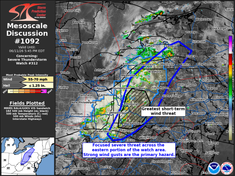
Mesoscale Discussion 1092 NWS Storm Prediction Center Norman OK 0248 PM CDT Thu Jun 11 2026 Areas affected...west-central Pennsylvania...western New York...western Maryland...and northern West Virginia Concerning...Severe Thunderstorm Watch 312... Valid 111948Z - 112145Z The severe weather threat for Severe Thunderstorm Watch 312 continues. SUMMARY...The severe weather threat continues across WW312, primarily across portions of southwestern Pennsylvania ahead of a more organized convective line. DISCUSSION...Several thunderstorm complexes have developed across western NY and PA, eastern OH, and northern WV. Some damaging wind reports have occurred as a result, particularly with the convective line in southwestern PA. KPBZ sampled around 50 kts around 700 ft ARL as the line passed at 1900z. Although bulk shear will remain on the modest side (around 20 kts), it should be sufficient to maintain more organized thunderstorm complexes as they move eastward into a region of MLCAPE around 2000+ J/kg. The greatest short-term threat for severe wind gusts will be in southwestern PA ahead of the organized convective line. Strong thunderstorms have also formed in western NY along the northern periphery of the unstable airmass. Here, bulk shear is slightly more supportive of discrete rotating updrafts (as evidenced by some low-level rotation in the cells east of Buffalo, NY as of 1945z) but buoyancy is more limited. A local wind and small hail threat could persist here with any sustained storm. Additional convection in the western portions of WW312 may also pose a short-term severe threat, but should be tempered by cold outflow (10-15 F deficits) in the wake of the leading convection. ..Flournoy.. 06/11/2026 ...Please see www.spc.noaa.gov for graphic product... ATTN...WFO...BGM...BUF...CTP...LWX...PBZ...RLX... LAT...LON 40987991 41597960 42317858 42967749 43157687 42737615 41527733 40067830 39377929 39048002 38988052 39238081 40318013 40987991 MOST PROBABLE PEAK WIND GUST...55-70 MPH MOST PROBABLE PEAK HAIL SIZE...UP TO 1.25 IN |
|
|
Top/All Mesoscale Discussions/Forecast Products/Home |
|
Source link