| Mesoscale Discussion 1091 | |
| < Previous MD | |

|
|
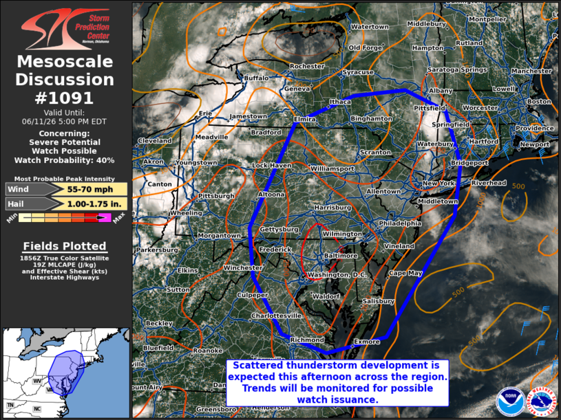
Mesoscale Discussion 1091 NWS Storm Prediction Center Norman OK 0202 PM CDT Thu Jun 11 2026 Areas affected...the Mid-Atlantic into southern New York and southwestern New England Concerning...Severe potential...Watch possible Valid 111902Z - 112100Z Probability of Watch Issuance...40 percent SUMMARY...Scattered thunderstorm development is expected this afternoon across the mid-Atlantic northward into southern New York and southwestern New England. Severe wind gusts and hail are possible with the strongest storms. DISCUSSION...Some deeper convective attempts are underway this afternoon across portions of the mid-Atlantic, particularly in southern New York as of 1900z. This development is occurring in a warm, unstable airmass with surface temperatures in the upper 80s and lower 90s F and MLCAPE values around 2000+ J/kg. The 18z ALB/Albany, NY sounding sampled the northern periphery of this airmass (along the CAPE gradient) with 0-6-km shear of 24 kts. This has supported some sporadic, more organized thunderstorm development recently. As the afternoon progresses, diurnal heating should support additional thunderstorm development across the region. Furthermore, a mid-level impulse in eastern OH -- influencing the ongoing convection in WW312 -- will continue moving eastward and should provide additional support for convective initiation and maturation. Bulk shear is expected to remain generally in the 15-25 kt range which, amidst forecast large MLCAPE around 2500-3000 J/kg, will promote strong updrafts capable of producing wind gusts and hail. Uncertainty remains as to how much convection will develop and coalesce/strengthen in the short term, but trends will continue to be monitored for possible watch issuance this afternoon. ..Flournoy/Gleason.. 06/11/2026 ...Please see www.spc.noaa.gov for graphic product... ATTN...WFO...OKX...ALY...PHI...BGM...AKQ...CTP...LWX... LAT...LON 39937855 42097738 42657579 42777436 42337326 41237290 40177310 37717495 37397648 37777765 38937842 39937855 MOST PROBABLE PEAK WIND GUST...55-70 MPH MOST PROBABLE PEAK HAIL SIZE...1.00-1.75 IN |
|
|
Top/All Mesoscale Discussions/Forecast Products/Home |
|
Source link