| Mesoscale Discussion 109 | |
| < Previous MD | |
|
|
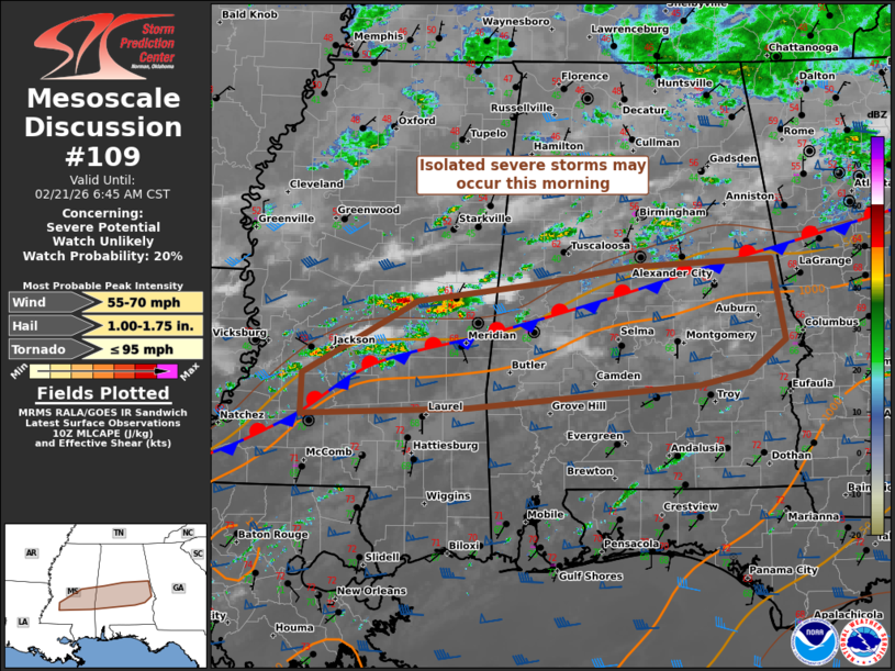
   Mesoscale Discussion 0109
   NWS Storm Prediction Center Norman OK
   0409 AM CST Sat Feb 21 2026

   Areas affected...central/southern parts of MS/AL

   Concerning...Severe potential...Watch unlikely

   Valid 211009Z - 211245Z

   Probability of Watch Issuance...20 percent

   SUMMARY...Isolated severe storms may develop this morning from
   initially elevated cells over parts of central Mississippi, as they
   spread east-southeast along a quasi-stationary front.

   DISCUSSION...As-advertised by the 00Z ECMWF/HREF and 06Z REFS
   guidance, convective development has been increasing along the MS
   portion of a quasi-stationary front in the Deep South. A pronounced
   low-level thermodynamic gradient across the boundary, along with
   moderate southwesterlies, has aided in isentropic ascent to the cool
   side of the front. Recent HRRR guidance has been quite insistent on
   a sustained rotating storm or two along the front, as cells shift
   into AL through mid-morning. Deep-layer shear is certainly favorable
   for mid-level rotation. However, weak to modest mid-level lapse
   rates should curtail hail growth to an extent. But with the presence
   of rich low-level moisture south of the front, there is concern that
   a near-boundary supercell could eventually attain surface-based
   character beyond a severe hail threat. However, low-level winds are
   expected to become slightly more veered from the west-southwest
   towards and after daybreak, which may help modulate the overall
   threat.

   ..Grams/Guyer.. 02/21/2026

   ...Please see www.spc.noaa.gov for graphic product...

   ATTN...WFO...BMX...MOB...JAN...

   LAT...LON   32758922 32918789 33078681 33148532 32378517 32088556
               31958612 31758866 31679050 32069050 32758922

   MOST PROBABLE PEAK TORNADO INTENSITY...UP TO 95 MPH
   MOST PROBABLE PEAK WIND GUST...55-70 MPH
   MOST PROBABLE PEAK HAIL SIZE...1.00-1.75 IN
|
|
|
Top/All Mesoscale Discussions/Forecast Products/Home |
|
Source link