| Mesoscale Discussion 1081 | |
| < Previous MD | |

|
|
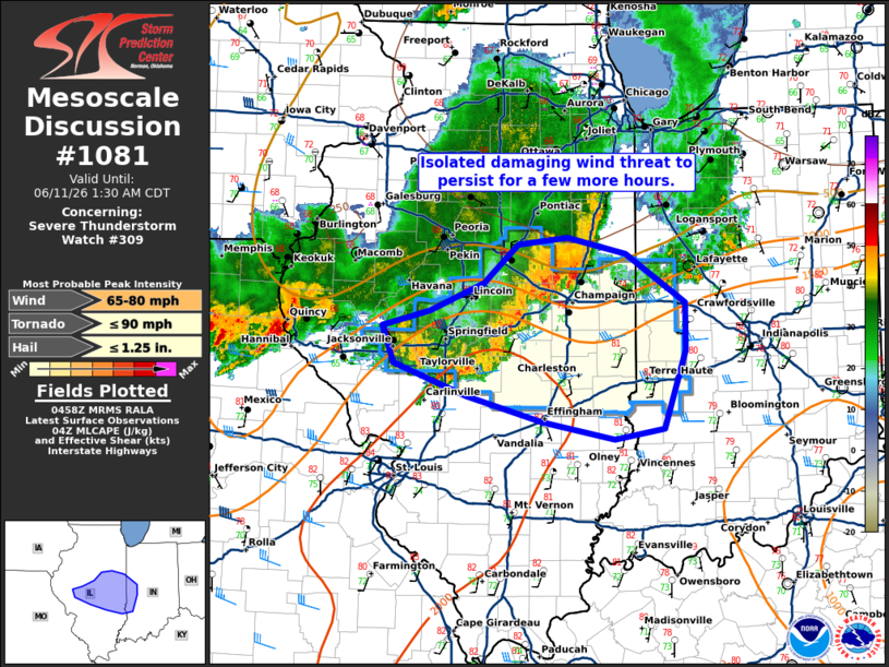
Mesoscale Discussion 1081 NWS Storm Prediction Center Norman OK 1200 AM CDT Thu Jun 11 2026 Areas affected...Portions of central and east-central Illinois into western Indiana. Concerning...Severe Thunderstorm Watch 309... Valid 110500Z - 110630Z The severe weather threat for Severe Thunderstorm Watch 309 continues. SUMMARY...Isolated damaging wind gusts will persist for a few more hours. DISCUSSION...A line of storms continues east across central Illinois. This line of storms has a history of wind damage and shows strong outbound winds from KILX. Expect this line of storms to persist eastward into a moderately unstable airmass (2000 to 2500 J/kg MUCAPE per SPC mesoanalysis) with a strengthening low-level jet feeding this activity from the southwest. This line of storms will likely pose a continued damaging wind threat for a few more hours before eventually weakening. Severe thunderstorm watch 309 has been expanded eastward/southeastward to cover this continued threat. ..Bentley.. 06/11/2026 ...Please see www.spc.noaa.gov for graphic product... ATTN...WFO...IND...LOT...ILX...LSX... LAT...LON 39589021 39919034 40048981 40288921 40618883 40678829 40538764 40118698 39698697 39038722 38948776 39088857 39308941 39589021 MOST PROBABLE PEAK TORNADO INTENSITY...UP TO 90 MPH MOST PROBABLE PEAK WIND GUST...65-80 MPH MOST PROBABLE PEAK HAIL SIZE...UP TO 1.25 IN |
|
|
Top/All Mesoscale Discussions/Forecast Products/Home |
|
Source link