| Mesoscale Discussion 1079 | |
| < Previous MD Next MD > | |

|
|
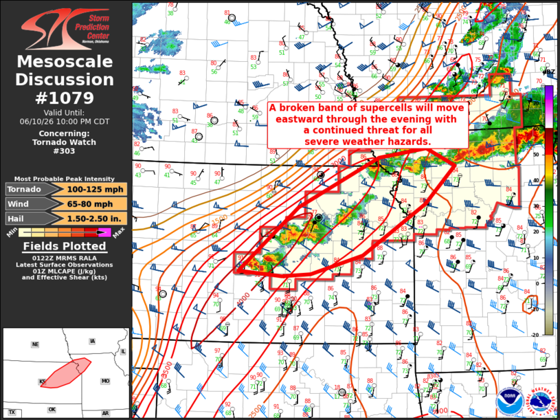
Mesoscale Discussion 1079 NWS Storm Prediction Center Norman OK 0824 PM CDT Wed Jun 10 2026 Areas affected...central to northeast Kansas into parts of northwest Missouri. Concerning...Tornado Watch 303... Valid 110124Z - 110300Z The severe weather threat for Tornado Watch 303 continues. SUMMARY...A broken band of supercells will move eastward through the evening with a continued threat for all severe weather hazards. DISCUSSION...Several supercells are ongoing from central Kansas into northeast Kansas this evening. The environment remains very favorable across this region with ~3000 J/kg MLCAPE and ~ 50 knots of effective shear on the 00Z TOP RAOB. In addition, a clockwise turned low-level hodograph will support a continued tornado threat with a STP around 2 to 2.5. Surface-based instability will lessen as the boundary layer cools this evening, but as the low-level jet strengthens, low-level shear will continue to increase. Therefore, some tornado threat will likely persist through the evening. Tornado watch 303 will need to be extended a few hours to address this threat. Later this evening, the surface front that these storms developed along will move northward as a surface low deepens and moves northward across Kansas. As this occurs, ongoing supercells will likely become disconnected from the synoptic front and start to dissipate as CINH increases amid rising heights across the region. ..Bentley.. 06/11/2026 ...Please see www.spc.noaa.gov for graphic product... ATTN...WFO...EAX...OAX...TOP...ICT... LAT...LON 38219838 39309710 40149535 40289430 39989369 39349435 38489570 38179682 38129745 38219838 MOST PROBABLE PEAK TORNADO INTENSITY...100-125 MPH MOST PROBABLE PEAK WIND GUST...65-80 MPH MOST PROBABLE PEAK HAIL SIZE...1.50-2.50 IN |
|
|
Top/All Mesoscale Discussions/Forecast Products/Home |
|
Source link