|
|
| Mesoscale Discussion 1076 | |
| < Previous MD | |

|
|
   Mesoscale Discussion 1076
   NWS Storm Prediction Center Norman OK
   0855 AM CDT Thu May 30 2024

   Areas affected...northwest Texas

   Concerning...Severe potential...Watch unlikely

   Valid 301355Z - 301530Z

   Probability of Watch Issuance...20 percent

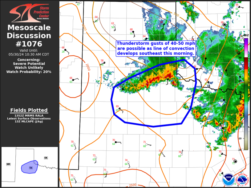
   SUMMARY...Sporadic strong gusts of 40-50 mph are possible with a
   line of thunderstorms developing southeast through the morning.

   DISCUSSION...A line of storms will continue to develop
   south/southeast across the Texas South Plains/northwest Texas
   vicinity this morning. Recent observations from the West Texas
   Mesonet indicated gusts of 40-50 mph have occurred near Wellington,
   while KCDS gusted to 63 mph. This activity will continue to move
   into an unstable airmass characterized by low to mid 60s F dewpoints
   and around 1000 J/kg MLCAPE. Portions of the downstream airmass have
   likely been impacted by another cluster of storms that moved over
   this area and is now located of north Texas. At least weak low-level
   inhibition is evident in regional 12z RAOBs and latest SPC
   Mesoanalysis. As a result of impacts from prior convection and a
   still weakly capped environment, expect convection to largely remain
   sub-severe in this short term, with gusts mostly in the 40-50 mph
   range possible, though isolated locally stronger gusts will be
   possible. A watch is not expected at this time.

   ..Leitman/Guyer.. 05/30/2024

   ...Please see www.spc.noaa.gov for graphic product...

   ATTN...WFO...OUN...SJT...LUB...AMA...

   LAT...LON   34810053 34949973 34709940 34339937 33649954 33249985
               33170074 33280163 33480198 33870207 34200200 34450151
               34810053
|
|
|
Top/All Mesoscale Discussions/Forecast Products/Home |
|


