|
|
| Mesoscale Discussion 1074 | |
| < Previous MD | |

|
|
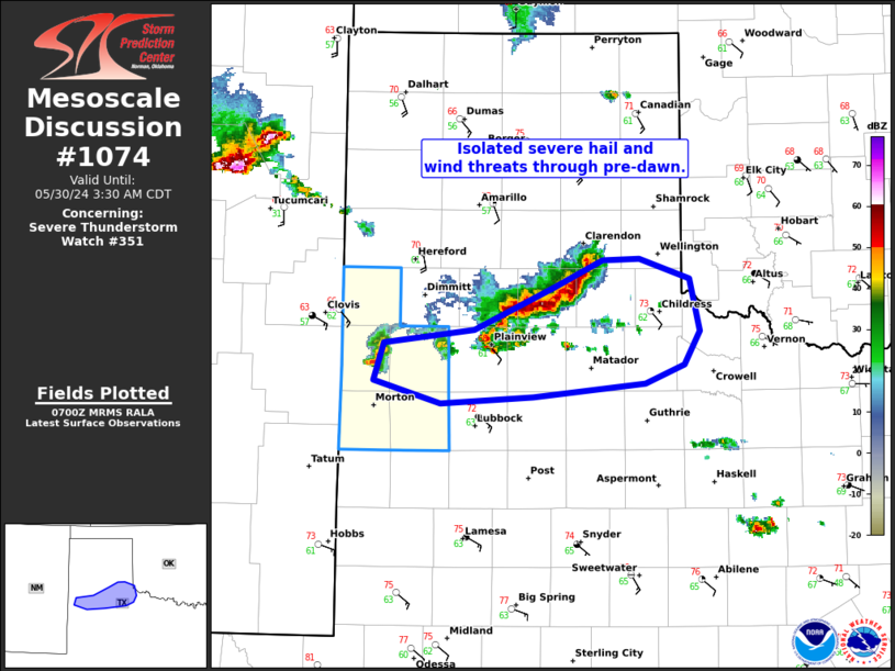
Mesoscale Discussion 1074 NWS Storm Prediction Center Norman OK 0202 AM CDT Thu May 30 2024 Areas affected...northwest TX Concerning...Severe Thunderstorm Watch 351... Valid 300702Z - 300830Z The severe weather threat for Severe Thunderstorm Watch 351 continues. SUMMARY...The severe threat appears to be diminishing within WW 351, while an isolated severe hail/wind threat should persist farther east in a portion of northwest Texas. DISCUSSION...The longer-lived supercell that produced significant severe in east-central NM, weakened substantially as it shifted eat into the TX South Plains. This appears to be in response to impinging on greater MLCIN, despite larger buoyancy to its southeast. Meanwhile, a cluster flare-up has occurred downstream towards the southeast TX Panhandle. This cluster has shown some organization, although the cluster mode appears to be limiting hail magnitudes. Isolated severe hail will probably remain most prominent within the southwest portion of this cluster development back to the remnant supercell. Localized severe wind gusts may become the overarching threat as the cluster gradually shifts east. How long this threat will last is uncertain, but it's plausible it will continue through the rest of pre-dawn. ..Grams.. 05/30/2024 ...Please see www.spc.noaa.gov for graphic product... ATTN...WFO...OUN...LUB...AMA... LAT...LON 34190267 34280186 34610113 34800071 34810037 34679993 34279983 34029997 33880033 33780133 33740216 33900275 34190267 |
|
|
Top/All Mesoscale Discussions/Forecast Products/Home |
|


