|
|
| Mesoscale Discussion 1072 | |
| < Previous MD | |

|
|
   Mesoscale Discussion 1072
   NWS Storm Prediction Center Norman OK
   0918 PM CDT Wed May 29 2024

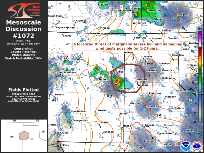
   Areas affected...Far eastern New Mexico and the southwestern Texas
   Panhandle

   Concerning...Severe potential...Watch unlikely

   Valid 300218Z - 300315Z

   Probability of Watch Issuance...20 percent

   SUMMARY...A localized threat of marginally severe hail around
   1-1.75" in diameter and severe wind gusts will be possible over the
   next 1-2 hours.

   DISCUSSION...A cluster of thunderstorms has rapidly developed along
   an outflow boundary across portions of far eastern NM. Recent radar
   imagery from KFDX and KAMA indicates there are two significant
   updrafts very close to the KFDX radar, with the southern most one
   being a supercell. Maintenance of these updrafts should remain
   favorable for at least another 1-2 hours considering increasing deep
   layer shear, steep mid-level lapse rates, and LLJ enhancement
   juxtaposed with a narrow instability axis just to their east. As
   these storms progress even further east later tonight, they will
   encounter increasing CINH and poorer mid-level lapse rates. A WW is
   not likely at this time as coverage should remain fairly limited.

   ..Barnes/Hart.. 05/30/2024

   ...Please see www.spc.noaa.gov for graphic product...

   ATTN...WFO...LUB...AMA...ABQ...

   LAT...LON   34640369 35240379 35560316 35590265 35520215 35170189
               34730196 34310236 34300284 34340328 34430356 34640369
|
|
|
Top/All Mesoscale Discussions/Forecast Products/Home |
|


