|
|
| Mesoscale Discussion 1067 | |
| < Previous MD | |

|
|
   Mesoscale Discussion 1067
   NWS Storm Prediction Center Norman OK
   0247 PM CDT Wed May 29 2024

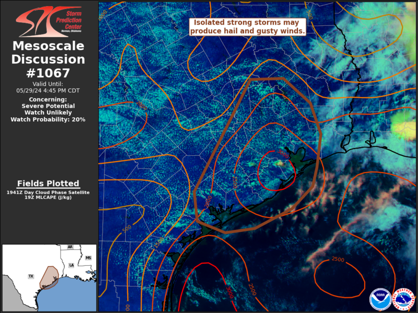
   Areas affected...southeast TX

   Concerning...Severe potential...Watch unlikely

   Valid 291947Z - 292145Z

   Probability of Watch Issuance...20 percent

   SUMMARY...Isolated strong thunderstorms are possible through early
   evening. Locally gusty winds of 45-60 mph and hail to near 1 inch
   diameter are possible with these storms.

   DISCUSSION...Visible satellite shows a deepening cumulus field
   across southeast Texas this afternoon, and convective initiation
   appears close in convection near Houston. Strong heating and surface
   dewpoints in the 70s F, in addition to near 7 C/km midlevel lapse
   rates, are contributing to MLCAPE up to 2500 J/kg. Southeasterly
   low-level flow becoming west/northwesterly in the mid/upper levels
   is resulting in effective shear values near 30 kt. Furthermore,
   forecast soundings show elongated/straight hodographs. This will
   support at least transient supercells and semi-organized clusters
   capable of near 1 inch diameter hail. A somewhat dry EML and PW
   values around 1.75-2 inches also will support strong gusts.
   Convection is expected to remain somewhat isolated and severe
   potential overall appears limited, and a watch is not currently
   expected.

   ..Leitman/Guyer.. 05/29/2024

   ...Please see www.spc.noaa.gov for graphic product...

   ATTN...WFO...LCH...HGX...CRP...EWX...

   LAT...LON   31009582 31039513 30579457 30029435 29419444 29079454
               28679497 28329572 28249632 28459689 28979696 31009582
|
|
|
Top/All Mesoscale Discussions/Forecast Products/Home |
|


