| Mesoscale Discussion 1066 | |
| < Previous MD | |

|
|
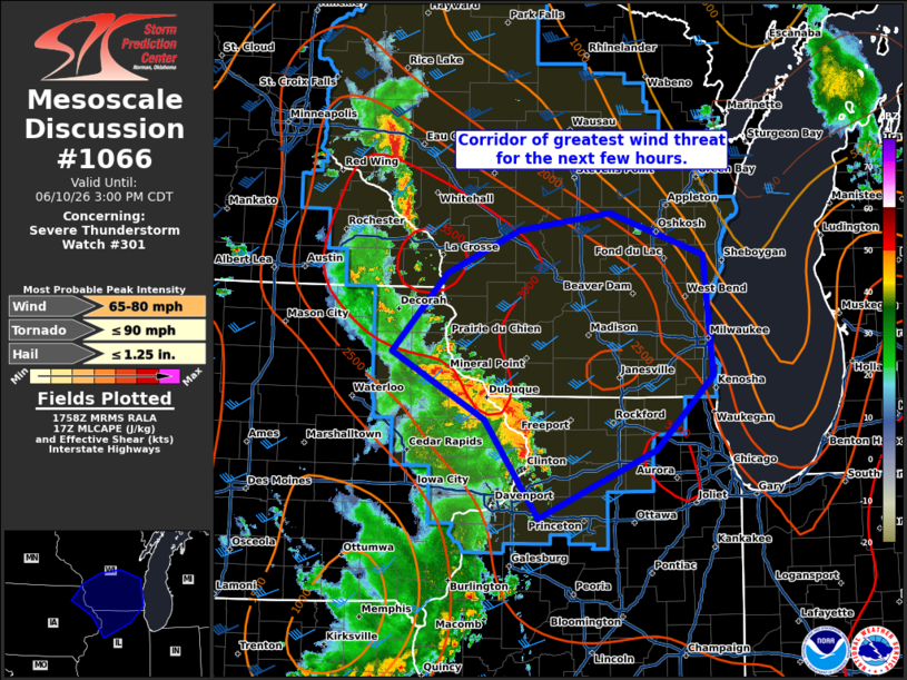
Mesoscale Discussion 1066 NWS Storm Prediction Center Norman OK 0100 PM CDT Wed Jun 10 2026 Areas affected...southern Wisconsin and northern Illinois Concerning...Severe Thunderstorm Watch 301... Valid 101800Z - 102000Z The severe weather threat for Severe Thunderstorm Watch 301 continues. SUMMARY...An arcing line of thunderstorms has organized in eastern Iowa and will move northeastward for the next few hours through WW 301. The threat for severe wind gusts is greatest in the delineated area as the system moves through. DISCUSSION...A line of severe thunderstorms has developed in eastern IA and is moving northeastward into southern WI and northern IL. A 64-kt wind gust was reported at 1740z in Dubuque, IA associated with this convection. Difluence aloft and low-level convergence along the leading edge of a ~10-F-deficit cold pool have likely contributed to storm strengthening during the last hour or so. Per current mesoanalysis, the line of storms is moving into a CAPE axis stretching from central IN northwestward into southeastern MN, featuring 2500+ J/kg along the WI/IL border. Bulk shear magnitudes are around 40 kts and southwesterly, oriented perpendicular to the convective line. This environment will support a threat for continued severe wind gusts as the system moves northeast for the next few hours. ..Flournoy.. 06/10/2026 ...Please see www.spc.noaa.gov for graphic product... ATTN...WFO...GRB...LOT...MKX...DVN...ARX... LAT...LON 42909185 43639117 44029026 44198911 43798795 42698784 42008854 41379002 42289068 42909185 MOST PROBABLE PEAK TORNADO INTENSITY...UP TO 90 MPH MOST PROBABLE PEAK WIND GUST...65-80 MPH MOST PROBABLE PEAK HAIL SIZE...UP TO 1.25 IN |
|
|
Top/All Mesoscale Discussions/Forecast Products/Home |
|
Source link