|
|
| Mesoscale Discussion 1065 | |
| < Previous MD Next MD > | |

|
|
   Mesoscale Discussion 1065
   NWS Storm Prediction Center Norman OK
   0118 PM CDT Wed May 29 2024

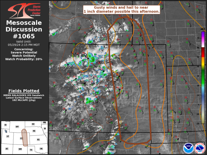
   Areas affected...portions of southeast WY...western NE...eastern CO
   and far northeast NM

   Concerning...Severe potential...Watch unlikely

   Valid 291818Z - 292015Z

   Probability of Watch Issuance...20 percent

   SUMMARY...Initial thunderstorm activity this afternoon will be
   capable of gusty winds and hail approaching 1 inch diameter.

   DISCUSSION...Thunderstorms are starting to develop over higher
   terrain early this afternoon as strong heating overlaps with
   increasing large-scale ascent. Boundary-layer moisture will remain
   modest with dewpoints generally in the 40s F near and immediately
   east of the I-25 corridor. Deep boundary-layer mixing is resulting
   in inverted-v type sub-cloud thermodynamic profiles, and steep
   low-level lapse rates greater than 9 C/km are noted in recent SPC
   Mesoanalysis data. This suggests storms moving off higher terrain
   into the adjacent high Plains may produce strong downdrafts and
   locally strong to severe gusts. Steep midlevel lapse rates will
   contribute to further destabilization, with MLCAPE to around 1000
   J/kg expected. Vertical shear will remain weak, limiting longevity
   of stronger updrafts. Nevertheless, cool temperature aloft and steep
   lapse rates may support marginal hail with this initial convection.

   Initial severe potential closer to the I-25 corridor appears limited
   and a watch is not expected at this time. With time, somewhat
   greater boundary layer moisture will advect westward into far
   eastern CO/southwest NE/western KS. Severe potential may increase
   with eastward extent later this afternoon or evening, and this risk
   will be addressed in later MCDs.

   ..Leitman/Guyer.. 05/29/2024

   ...Please see www.spc.noaa.gov for graphic product...

   ATTN...WFO...GLD...PUB...BOU...CYS...ABQ...

   LAT...LON   40990545 41610556 42180495 42270444 42090386 41550342
               40760321 36690301 36540325 36470381 36500434 36680473
               36840474 39060512 40320541 40990545
|
|
|
Top/All Mesoscale Discussions/Forecast Products/Home |
|


