| Mesoscale Discussion 1064 | |
| < Previous MD | |

|
|
Mesoscale Discussion 1064
NWS Storm Prediction Center Norman OK
1109 AM CDT Wed Jun 10 2026
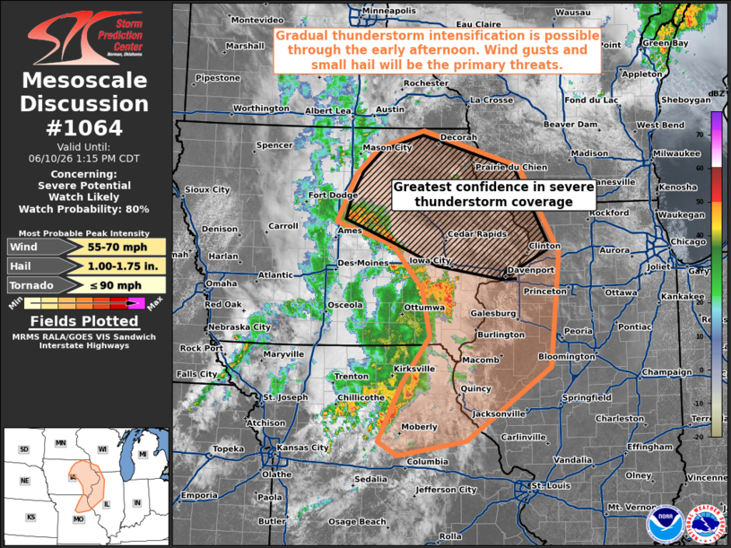
Areas affected...Eastern Iowa...northeastern Missouri...southwestern
Wisconsin...and northwestern Illinois
Concerning...Severe potential...Watch likely
Valid 101609Z - 101815Z
Probability of Watch Issuance...80 percent
SUMMARY...Scattered thunderstorms are currently moving northeastward
through central Iowa and northeastern Missouri. These storms may
gradually strengthen in the next couple of hours, posing a threat
for wind gusts and small hail. A watch will likely be needed soon in
the northern portion of the highlighted area.
DISCUSSION...A couple of thunderstorm complexes are moving through
central IA and northeastern MO this morning. A few 40+ kt gusts have
been reported across central IA with the strongest cores. Per
current mesoanalysis, they are located along the leading edge of a
mid-level impulse propagating through IA in a zone of broad
upper-level difluence. Modest heating amidst scattered cloud cover
is yielding gradual warming into the low-/mid-80s F which --
combined with dewpoints in the lower 70s F -- supports MLCAPE around
1500 J/kg ahead of the storms. Bulk shear is around 25-30 kts,
increasing to around 30-35 kts in the northern portion of the
highlighted area.
The general expectation is for these storms to gradually intensify
as they move northeastward during the next couple of hours.
Convective evolution remains uncertain; some high-resolution
guidance depicts a consolidated cold pool and bowing system, while
others depict more discrete through early afternoon. Regardless of
mode, the background environment should support a gradually
ramping-up threat for wind gusts and small hail. Watch issuance is
likely in the short term in the delineated area to cover these
threats.
..Flournoy/Mosier.. 06/10/2026
...Please see www.spc.noaa.gov for graphic product...
ATTN...WFO...LOT...ILX...MKX...LSX...DVN...ARX...DMX...EAX...
LAT...LON 40308978 39319127 39109248 39299281 40089239 40709192
41359206 41939258 42239359 42869326 43229286 43469204
42989031 41838962 40308978
MOST PROBABLE PEAK TORNADO INTENSITY...UP TO 90 MPH
MOST PROBABLE PEAK WIND GUST...55-70 MPH
MOST PROBABLE PEAK HAIL SIZE...1.00-1.75 IN
|
|
|
Top/All Mesoscale Discussions/Forecast Products/Home |
|
Source link