| Mesoscale Discussion 1055 | |
| < Previous MD | |

|
|
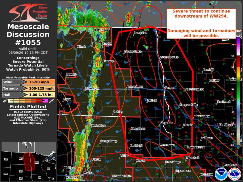
Mesoscale Discussion 1055 NWS Storm Prediction Center Norman OK 0841 PM CDT Tue Jun 09 2026 Areas affected...eastern Dakotas and western Minnesota Concerning...Severe potential...Tornado Watch likely Valid 100141Z - 100315Z Probability of Watch Issuance...80 percent SUMMARY...Severe potential to extend downstream of WW294. Thunderstorms with potential for damaging wind and tornadoes will move eastward through the evening. DISCUSSION...Thunderstorm activity is increasing along the front in the central Dakotas. This activity has been producing wind gusts 60-70+ mph. The mode is becoming linearly forced along the front, given deep layer shear vectors parallel to the front. This will likely remain the case through the evening, with surface objective analysis and recent 00z soundings from ABR and BIS indicating steep low level lapse rates and large MLCAPE around 2500-3000 J/kg amid temperatures in the 80s-90s F. The low-level jet is expected to increase through the evening as the surface low across North Dakota deepens and shifts northward into Canada. This will support an increase in south to southeasterly low-level flow which will enlarge hodographs and enhance low-level SRH. This will promote potential for line embedded vorticies and a couple of tornadoes into the evening/overnight. A new watch will likely be needed downstream of WW294 soon. ..Thornton/Smith.. 06/10/2026 ...Please see www.spc.noaa.gov for graphic product... ATTN...WFO...MPX...FGF...FSD...ABR...BIS... LAT...LON 47839956 48849912 49039747 48749632 47489534 44679549 44509652 44449765 44609853 47839956 MOST PROBABLE PEAK TORNADO INTENSITY...100-125 MPH MOST PROBABLE PEAK WIND GUST...75-90 MPH MOST PROBABLE PEAK HAIL SIZE...1.00-1.75 IN |
|
|
Top/All Mesoscale Discussions/Forecast Products/Home |
|
Source link