| Mesoscale Discussion 1053 | |
| < Previous MD | |

|
|
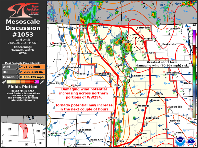
Mesoscale Discussion 1053 NWS Storm Prediction Center Norman OK 0718 PM CDT Tue Jun 09 2026 Areas affected...central Dakotas Concerning...Tornado Watch 294... Valid 100018Z - 100215Z The severe weather threat for Tornado Watch 294 continues. SUMMARY...Damaging wind potential increasing across northern portions of WW294 in central North Dakota. Tornado potential may increase over the next couple of hours. DISCUSSION...Thunderstorm development continues along the cold front in the central Dakotas this evening. Mode has favored quick transition from supercell to clusters given mean layer shear vectors largely parallel to the front. Nonetheless, a few supercells have produced hail up to 1.5-3 inches in diameter. Across central North Dakota, radar analysis shows the cluster in Ward/Mclean County developing a bowing structure, with winds around 60-75 kts around 1 kft as viewed from KBIS and KMBX. Winds up to 72 mph have been reported near Sawyer, ND. The area ahead of this line will be a favored region for significant damaging wind (75-80+ mph) potential in the short term due to steep low level lapse rates, evaporative processes, and fast storm motions with these storms. Tornado potential continues and may increase through the evening. Initial storms developed in the lower dew point air mass across the western Dakotas and are now moving into a region of richer low-level moisture. While the mode may not favor maintenance of discrete cells, line embedded circulations will pose potential for tornadoes through the evening as the low-level jet enhances low level SRH. ..Thornton.. 06/10/2026 ...Please see www.spc.noaa.gov for graphic product... ATTN...WFO...FGF...ABR...BIS...UNR... LAT...LON 46880158 47580256 48350337 48830356 49020348 49060308 48880078 48410000 47439963 46439962 45769983 45060004 44410020 44070082 43830183 44760183 46880158 MOST PROBABLE PEAK TORNADO INTENSITY...100-125 MPH MOST PROBABLE PEAK WIND GUST...75-90 MPH MOST PROBABLE PEAK HAIL SIZE...2.00-3.50 IN |
|
|
Top/All Mesoscale Discussions/Forecast Products/Home |
|
Source link