| Mesoscale Discussion 1051 | |
| < Previous MD | |

|
|
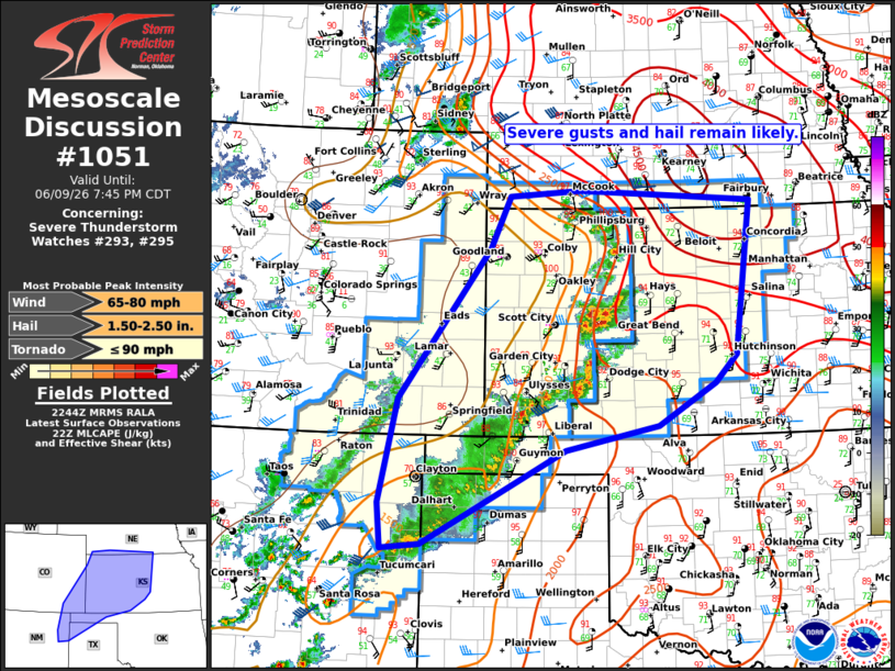
Mesoscale Discussion 1051 NWS Storm Prediction Center Norman OK 0545 PM CDT Tue Jun 09 2026 Areas affected...portions of eastern Colorado...western and central Kansas...the Panhandles and northeastern New Mexico Concerning...Severe Thunderstorm Watch 293...295... Valid 092245Z - 100045Z The severe weather threat for Severe Thunderstorm Watch 293, 295 continues. SUMMARY...Severe wind gusts and hail remain likely with numerous strong to severe storms this afternoon and evening. DISCUSSION...Across WW293 and WW295, numerous strong to severe storms are ongoing with reports of damaging gusts and some hail over the last couple of hours. Much of the air mass remains strongly mixed, but with sufficient buoyancy for strong updrafts. This will support the risk for severe winds given the steep low-level lapse rates and observed cluster storm mode. Occasional hail is also possible given the stronger updrafts, though buoyancy will be somewhat of a limiting factor. The easternmost storms have begun to encounter greater buoyancy over parts of western and central KS. Occasional supercell structures have also been noted which, along with the increased buoyancy may also favor a locally greater risk for large hail over the next couple of hours. ..Lyons.. 06/09/2026 ...Please see www.spc.noaa.gov for graphic product... ATTN...WFO...TOP...ICT...OUN...GID...DDC...GLD...AMA...PUB... ABQ... LAT...LON 37470347 39470195 40160163 40230044 40089757 38069784 37699820 37129915 36800069 35560306 35500371 36090376 37470347 MOST PROBABLE PEAK TORNADO INTENSITY...UP TO 90 MPH MOST PROBABLE PEAK WIND GUST...65-80 MPH MOST PROBABLE PEAK HAIL SIZE...1.50-2.50 IN |
|
|
Top/All Mesoscale Discussions/Forecast Products/Home |
|
Source link