|
|
| Mesoscale Discussion 1050 | |
| < Previous MD | |

|
|
   Mesoscale Discussion 1050
   NWS Storm Prediction Center Norman OK
   0213 PM CDT Tue May 28 2024

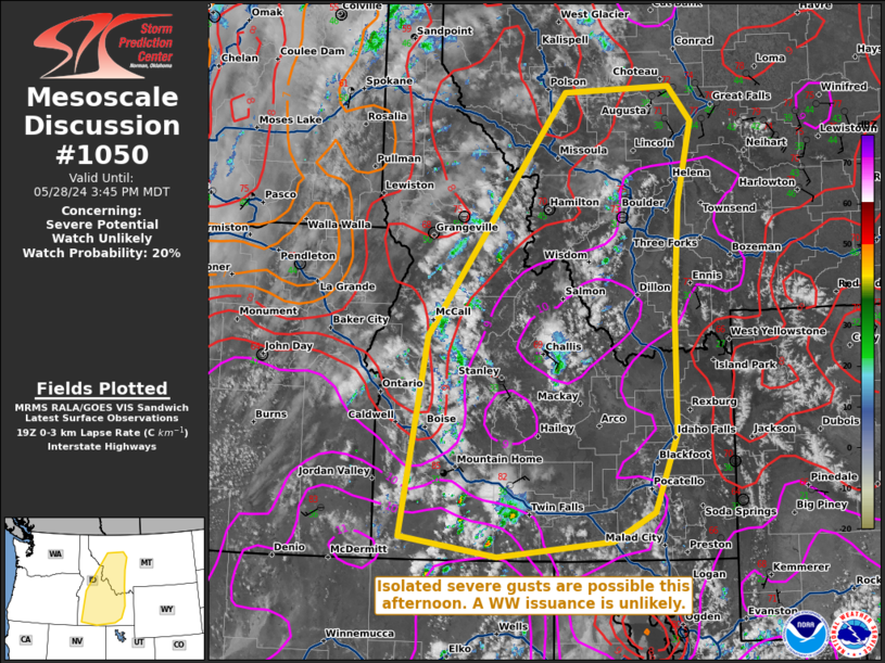
   Areas affected...portions of central...southern...and eastern Idaho
   into southwestern Montana

   Concerning...Severe potential...Watch unlikely

   Valid 281913Z - 282145Z

   Probability of Watch Issuance...20 percent

   SUMMARY...A couple of severe gusts will be possible with the
   stronger storms today. The severe threat should be sparse and a WW
   issuance is not expected.

   DISCUSSION...High-based thunderstorms are gradually increasing in
   coverage over portions of central ID into southwestern MT. These
   storms are developing atop a deep boundary layer, comprised of 9-10
   C/km surface-500 mb lapse rates (per latest RAP forecast soundings).
   The stronger, longer-lasting thunderstorms may generate enough
   evaporative cooling to support strong downbursts, where a couple of
   severe surface gusts may be observed. Still, the severe threat will
   be isolated, precluding the need of a WW issuance.

   ..Squitieri/Hart.. 05/28/2024

   ...Please see www.spc.noaa.gov for graphic product...

   ATTN...WFO...TFX...PIH...MSO...BOI...

   LAT...LON   42271660 44711616 47641384 47721205 47301167 46331191
               45001199 43531198 42571237 42221305 42031498 42271660
|
|
|
Top/All Mesoscale Discussions/Forecast Products/Home |
|


