| Mesoscale Discussion 1043 | |
| < Previous MD | |

|
|
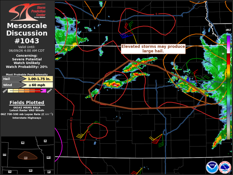
   Mesoscale Discussion 1043
   NWS Storm Prediction Center Norman OK
   0155 AM CDT Tue Jun 09 2026

   Areas affected...Parts of central/eastern Kansas

   Concerning...Severe potential...Watch unlikely

   Valid 090655Z - 090900Z

   Probability of Watch Issuance...20 percent

   SUMMARY...Isolated large hail and strong/marginally severe winds may
   occur with elevated storms. A watch is not anticipated given lack of
   greater storm coverage and marginal intensities.

   DISCUSSION...Warm advection top the outflow from a the earlier
   strong MCS has promoted the development of widely scattered storms.
   Steep lapse rates remain in the wake of the earlier convection and
   effective shear is 45-55 kt. Isolated large hail and perhaps a
   strong to marginally severe wind gusts will be possible with this
   activity into the early morning hours.

   ..Wendt/Guyer.. 06/09/2026

   ...Please see www.spc.noaa.gov for graphic product...

   ATTN...WFO...TOP...ICT...GID...DDC...

   LAT...LON   38329858 38469951 38549983 38809996 39079958 39629857
               39469761 39049658 38639594 38439596 38359637 38319842
               38329858

   MOST PROBABLE PEAK WIND GUST...UP TO 60 MPH
   MOST PROBABLE PEAK HAIL SIZE...1.00-1.75 IN
|
|
|
Top/All Mesoscale Discussions/Forecast Products/Home |
|
Source link