| Mesoscale Discussion 104 | |
| < Previous MD | |

|
|
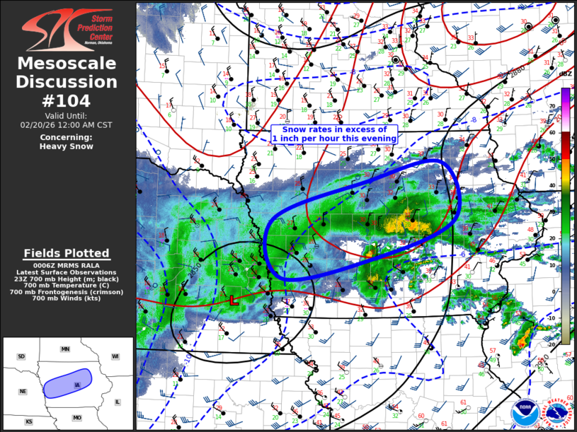
   Mesoscale Discussion 0104
   NWS Storm Prediction Center Norman OK
   0607 PM CST Thu Feb 19 2026

   Areas affected...Portions of Iowa

   Concerning...Heavy snow

   Valid 200007Z - 200600Z

   SUMMARY...Snow rates possibly exceeding 1 inch per hour are expected
   from western into central Iowa this evening.

   DISCUSSION...Water-vapor imagery suggests significant midlevel
   drying is spreading across southeast NE into southern IA, just south
   of expected 700mb low track. Latest radar data supports this with a
   well-developed corridor of heavy snow currently noted across eastern
   NE into western IA. Large-scale ascent is beginning to increase
   downstream into central IA, and precipitation is gradually expanding
   into this region within the warm advection zone. Forecast soundings
   exhibit steep midlevel lapse rates across  central IA, and
   reflectively suggests some convective nature with this new
   development that is spreading north. Over the next few hours a
   southwest-northeast oriented band of heavy snow should establish
   itself as the 700mb circulation advances east. Snow rates could
   exceed 1 inch per hour at times.

   ..Darrow.. 02/20/2026

   ...Please see www.spc.noaa.gov for graphic product...

   ATTN...WFO...DVN...ARX...DMX...FSD...OAX...

   LAT...LON   41199564 41499378 42119201 43019227 42729386 42109584
               41199564
|
|
|
Top/All Mesoscale Discussions/Forecast Products/Home |
|
Source link