| Mesoscale Discussion 1039 | |
| < Previous MD Next MD > | |

|
|
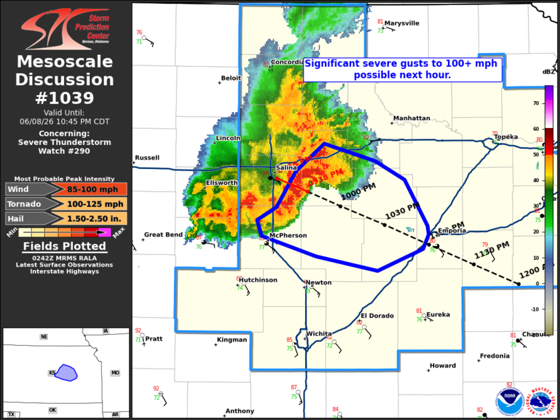
Mesoscale Discussion 1039 NWS Storm Prediction Center Norman OK 0944 PM CDT Mon Jun 08 2026 Areas affected...portions of central KS Concerning...Severe Thunderstorm Watch 290... Valid 090244Z - 090345Z The severe weather threat for Severe Thunderstorm Watch 290 continues. SUMMARY...Significant severe gusts of 100+ mph have occurred and may continue downstream of an intense bowing segment and merging supercell over the next hour. DISCUSSION...Recent radar and surface observations of the bowing complex across Saline and Dickinson Counties in KS show significant severe wind gust potential. The environment is extremely unstable and supportive of gusts over 100 mph. An internal surge within the bowing segment recently produced a measured 113 mph gust at KSLN. Additional significant gusts of 100+ mph are possible where a supercell is interacting with the gust front near the Saline/Dickinson county line. The significant wind threat may continue over the next hour as the bowing complex surges southeastward. ..Lyons.. 06/09/2026 ...Please see www.spc.noaa.gov for graphic product... ATTN...WFO...TOP...ICT... LAT...LON 38849741 39049716 38919672 38789645 38479625 38419624 38319629 38169669 38259723 38409772 38519776 38599758 38849741 MOST PROBABLE PEAK TORNADO INTENSITY...100-125 MPH MOST PROBABLE PEAK WIND GUST...85-100 MPH MOST PROBABLE PEAK HAIL SIZE...1.50-2.50 IN |
|
|
Top/All Mesoscale Discussions/Forecast Products/Home |
|
Source link