|
|
| Mesoscale Discussion 1038 | |
| < Previous MD | |

|
|
   Mesoscale Discussion 1038
   NWS Storm Prediction Center Norman OK
   1013 AM CDT Tue May 28 2024

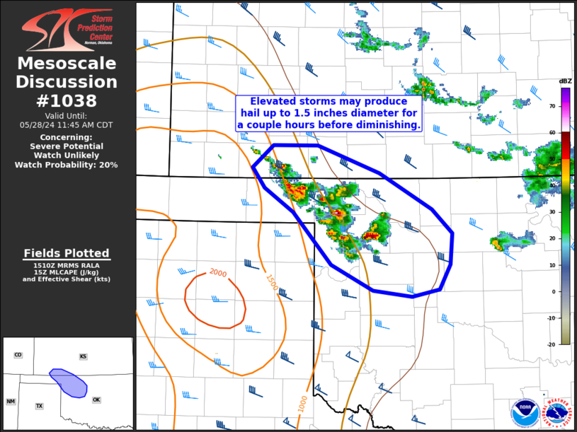
   Areas affected...northwest OK into adjacent southwest KS

   Concerning...Severe potential...Watch unlikely

   Valid 281513Z - 281645Z

   Probability of Watch Issuance...20 percent

   SUMMARY...Isolated hail to around 1.75 inches diameter is possible
   the next 1-2 hours across northwest Oklahoma into adjacent southwest
   Kansas.

   DISCUSSION...Elevated thunderstorms have developed this morning in
   an area of low-level east/southeasterly flow beneath upper northwest
   flow. Very steep midlevel lapse rates are supporting modest
   instability. VWP data from KVNX shows elongated hodographs above 2-3
   km amid deeper shear supporting transient supercells. This activity
   will be capable of producing severe hail to near 1.75 inches over
   the next 1-2 hours. With southward extent, overnight convection and
   outflow has modified the airmass into parts of southwest and central
   OK. The expectation is that this cluster of storms should gradually
   decrease in intensity with southeast extent over the next couple of
   hours. Trends will be monitored but watch issuance is not currently
   expected.

   ..Leitman/Hart.. 05/28/2024

   ...Please see www.spc.noaa.gov for graphic product...

   ATTN...WFO...OUN...DDC...AMA...

   LAT...LON   37120086 37370057 37379996 37059909 36649837 36389809
               36029812 35759826 35679865 35739918 36029977 36610029
               36890069 37120086
|
|
|
Top/All Mesoscale Discussions/Forecast Products/Home |
|


