|
|
| Mesoscale Discussion 1026 | |
| < Previous MD | |

|
|
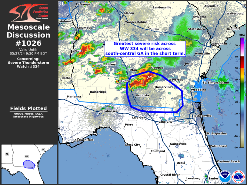
Mesoscale Discussion 1026 NWS Storm Prediction Center Norman OK 0701 PM CDT Mon May 27 2024 Areas affected...Southern Georgia Concerning...Severe Thunderstorm Watch 334... Valid 280001Z - 280130Z The severe weather threat for Severe Thunderstorm Watch 334 continues. SUMMARY...The severe threat across WW 334 continues, but will be more focused over the next hour or so across south-central Georgia where a more organized thunderstorm cluster will pose a severe wind threat. DISCUSSION...Convection continues to percolate across much of southern AL into central/southern GA. Recent MRMS trends show that the clustered nature of the storms has limited storm longevity and organization thus far, though a few more intense updrafts remain evident in GOES IR imagery, suggesting that sporadic/isolated severe hail and damaging winds remain possible across the region. A more focused/higher severe threat has materialized across far southern GA where cold pool amalgamation has resulted in a more organized cluster. Radar imagery from KVAX shows hints at horizontal convective rolls extending southwest to northeast aligned with the low-level wind. This feature suggests that a well-mixed, buoyant boundary layer remains in place immediately downstream of this cluster, and that low-level convergence should be enhanced on the southwestern flank of the cold pool, resulting in an increasingly southward propagation of the cluster. Consequently, the threat for damaging winds appears to be increasing across southern GA and potentially into far northern FL. ..Moore.. 05/28/2024 ...Please see www.spc.noaa.gov for graphic product... ATTN...WFO...JAX...TAE... LAT...LON 30518313 30598338 30758345 30958351 31188351 31338339 31468290 31368254 31148219 30998196 30628194 30468210 30478242 30488287 30518313 |
|
|
Top/All Mesoscale Discussions/Forecast Products/Home |
|


