|
|
| Mesoscale Discussion 1025 | |
| < Previous MD Next MD > | |

|
|
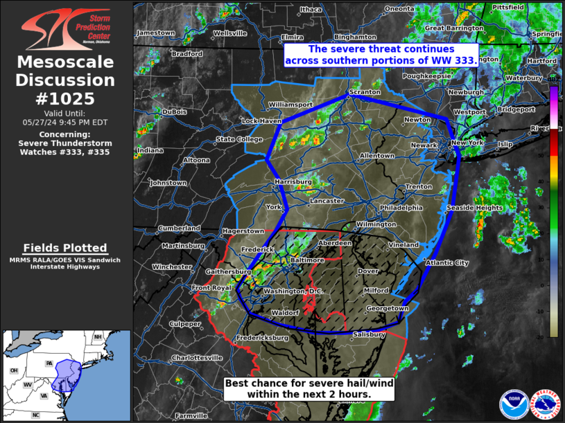
Mesoscale Discussion 1025 NWS Storm Prediction Center Norman OK 0640 PM CDT Mon May 27 2024 Areas affected...Southeast Pennsylvania into the Delmarva region Concerning...Severe Thunderstorm Watch 333...335... Valid 272340Z - 280145Z The severe weather threat for Severe Thunderstorm Watch 333, 335 continues. SUMMARY...The severe threat continues primarily for the southern half of WW 333, especially downstream of a cluster of organized convection moving across the Delmarva region. DISCUSSION...Gradual and modest air mass recovery has been ongoing over the past couple of hours across central to eastern PA and NJ in the wake of earlier convection. Recent RAP mesoanalysis estimates suggest MLCAPE has increased to around 1000 J/kg across eastern PA/NJ with strong deep-layer wind shear remaining over the region ahead of the approaching upper wave. Thunderstorms that have recently developed along a subtle surface confluence axis may see intensification to severe limits over the next hour or so before the onset of more substantial nocturnal cooling/stabilization. Further south, a cluster of discrete/semi-discrete cells has evolved over the Delmarva region. This activity remains well within the buoyancy axis where low 70s dewpoints are supporting MLCAPE closer to 1500 J/kg. With moisture continuing to increase downstream into DE, storm maintenance and/or intensification is expected with a continued threat for damaging winds and large hail. A brief tornado threat may materialize across the northern Chesapeake Bay area within the hour given modest (around 100 m2/s2) 0-1 km SRH just ahead of the ongoing storms, but southwesterly winds further downstream into DE suggest weaker low-level SRH and lower tornado potential. ..Moore.. 05/27/2024 ...Please see www.spc.noaa.gov for graphic product... ATTN...WFO...OKX...PHI...BGM...AKQ...CTP...LWX... LAT...LON 38567485 38477515 38437571 38437618 38537677 38667723 38857738 38987743 39217725 39547699 39717682 39987665 40367679 40617699 41087677 41437562 41127402 40647383 39967395 39427423 38977453 38837474 38567485 |
|
|
Top/All Mesoscale Discussions/Forecast Products/Home |
|


