|
|
| Mesoscale Discussion 1024 | |
| < Previous MD Next MD > | |

|
|
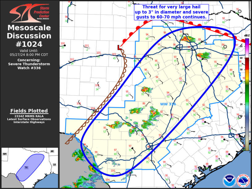
Mesoscale Discussion 1024 NWS Storm Prediction Center Norman OK 0636 PM CDT Mon May 27 2024 Areas affected...North/Central TX through te TX Hill Country Concerning...Severe Thunderstorm Watch 336... Valid 272336Z - 280100Z The severe weather threat for Severe Thunderstorm Watch 336 continues. SUMMARY...Threat for very large hail up to 3" in diameter and severe gusts around 60-70 mph will continue from north/central Texas into the Texas Hill Country. DISCUSSION...Strong to severe thunderstorms continue to develop within the very warm and moist airmass that exists from the TX Hill Country north and eastward across the remainder of the state. Large-scale ascent across the region remains fairly modest, with the low-level moisture convergence providing the primary mechanism for convective initiation. In addition to robust buoyancy, strong vertical shear exists over the region as well, with long hodographs favoring splitting storms. The overall environment supports the persistence of both left and right splits, with storm interactions dictating updraft survival. This is particularly true across central TX, where greater storm coverage exists, likely a result of subtle large-scale ascent aiding overall convective initiation and maturation. The very strong buoyancy and shear will continue to support the potential for very large hail up to 3" in diameter across the entire region. Steep low-level lapse rates will also support the development of strong downbursts capable of producing severe gusts around 60-70 mph. Weak surface winds are expected to keep the tornado threat low, although non-zero given the supercellular storm mode. ..Mosier.. 05/27/2024 ...Please see www.spc.noaa.gov for graphic product... ATTN...WFO...SHV...FWD...CRP...EWX...SJT... LAT...LON 31229980 33229773 33209526 31779580 28519940 29390112 31229980 |
|
|
Top/All Mesoscale Discussions/Forecast Products/Home |
|


