|
|
| Mesoscale Discussion 1023 | |
| < Previous MD | |

|
|
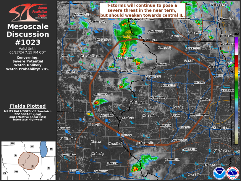
   Mesoscale Discussion 1023
   NWS Storm Prediction Center Norman OK
   0510 PM CDT Mon May 27 2024

   Areas affected...Eastern Iowa into central Illinois

   Concerning...Severe potential...Watch unlikely

   Valid 272210Z - 280015Z

   Probability of Watch Issuance...20 percent

   SUMMARY...Isolated thunderstorms will continue to pose a severe
   wind/hail risk as they move out of eastern Iowa and into far
   northwest Illinois. However, a gradual weakening trend is
   anticipated towards central IL later this evening.

   DISCUSSION...Isolated to scattered thunderstorms across eastern IA
   continue to show periodic intensification to severe limits based on
   regional velocity data and MRMS vertical ice/MESH metrics. Recent
   RAP mesoanalyses continue to show a supportive thermodynamic
   environment across eastern IA into northwest IL with MLCAPE around
   500 J/kg and nearly straight hodographs are noted in regional VWPs
   with around 30 knots of 0-6 km BWD. However, this activity appears
   to be slowly outrunning the cooler temperatures aloft and better
   low-level moisture that is supporting the buoyancy (downstream
   observations across central to northern IL show dewpoints mixing out
   into the upper 40s and low 50s). Some severe wind/hail threat will
   continue for the next few hours, but a gradual weakening trend
   appears likely as storms move deeper into IL later this evening.
   Given the limited environment and coverage of the threat, watch
   issuance is not anticipated.

   ..Moore/Smith.. 05/27/2024

   ...Please see www.spc.noaa.gov for graphic product...

   ATTN...WFO...LOT...ILX...MKX...LSX...DVN...ARX...DMX...EAX...

   LAT...LON   42179189 42509150 42579091 42388959 41788829 41528816
               40938820 40478854 39878919 39738976 39729044 39909112
               40229190 40499234 40889252 41339253 41849216 42179189
|
|
|
Top/All Mesoscale Discussions/Forecast Products/Home |
|