|
|
| Mesoscale Discussion 1022 | |
| < Previous MD | |

|
|
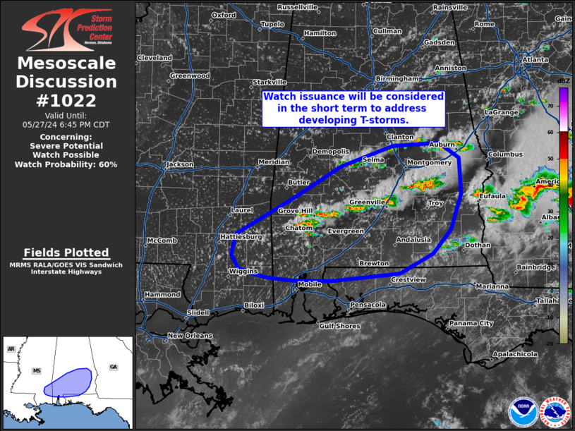
Mesoscale Discussion 1022 NWS Storm Prediction Center Norman OK 0442 PM CDT Mon May 27 2024 Areas affected...Southern Alabama Concerning...Severe potential...Watch possible Valid 272142Z - 272345Z Probability of Watch Issuance...60 percent SUMMARY...A severe thunderstorm watch is being considered to address convection developing to the west of WW 334 into southern and southwest Alabama. DISCUSSION...Over the past hour, scattered thunderstorms have developed along a residual outflow boundary across south-central to southwest AL with bubbling cumulus noted in GOES visible imagery further west into southeast MS. This convection is developing just to the west of WW 334, but should mature in a similar thermodynamic/kinematic environment characterized by roughly 3000 J/kg MLCAPE and 35-45 knots of effective bulk wind shear. Storm motions and deep-layer shear vectors oriented along the boundary should favor upscale growth into clusters with time (with an increasing wind threat), but a large hail threat should manifest in the short term (next 1-2 hours). ..Moore/Smith.. 05/27/2024 ...Please see www.spc.noaa.gov for graphic product... ATTN...WFO...TAE...BMX...MOB...JAN... LAT...LON 32668651 32698575 32498544 31998540 31508557 31188587 30918639 30818747 30818811 30858852 30908879 30988898 31158908 31448901 31668859 31968807 32388734 32668651 |
|
|
Top/All Mesoscale Discussions/Forecast Products/Home |
|


