|
|
| Mesoscale Discussion 1021 | |
| < Previous MD | |

|
|
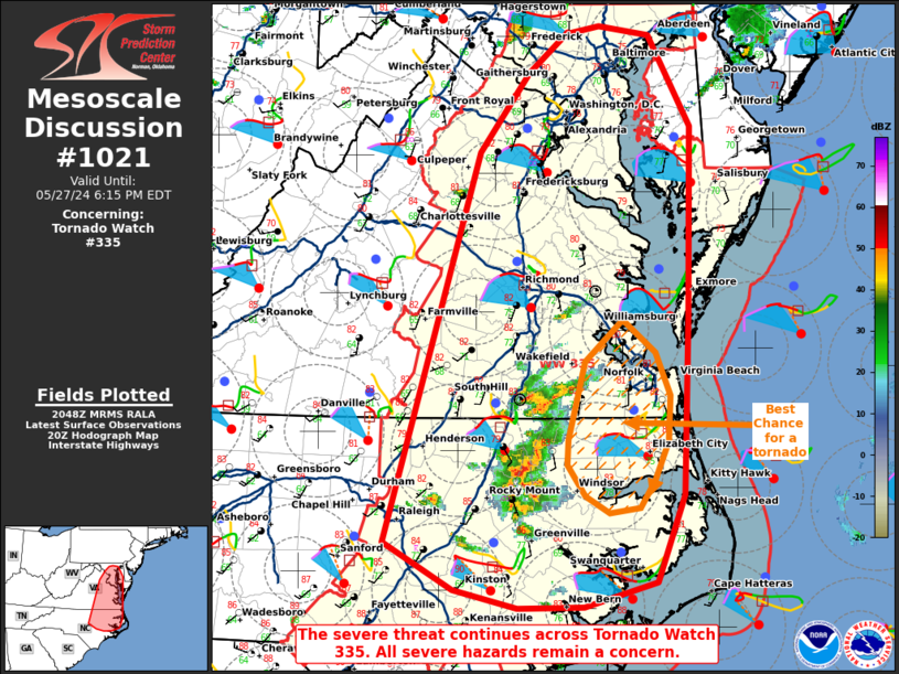
Mesoscale Discussion 1021 NWS Storm Prediction Center Norman OK 0349 PM CDT Mon May 27 2024 Areas affected...portions of eastern North Carolina and eastern Virginia Concerning...Tornado Watch 335... Valid 272049Z - 272215Z The severe weather threat for Tornado Watch 335 continues. SUMMARY...The severe threat continues across Tornado Watch 335. Large hail and damaging gusts remain a concern. The best chance for tornadoes would be closer to the coastline ahead of ongoing storms. DISCUSSION...Multicells and transient supercells persist across northeastern NC and are moving northeast toward southeast VA. At the moment, these are the most robust storms across eastern NC/VA, though an increase in thunderstorm coverage is possible later this afternoon. Given widespread 1000-3000 J/kg MLCAPE and 40+ kts of effective bulk shear, most thunderstorms should maintain a multicellular or transient supercell mode through the afternoon. While a tornado or two cannot be ruled out anywhere across Tornado Watch 335 in eastern NC/VA, the best chance for tornadoes appears to be far southeast VA/northeast NC closer to the coast, where backed low-level winds are contributing to slightly larger low-level hodographs. ..Squitieri.. 05/27/2024 ...Please see www.spc.noaa.gov for graphic product... ATTN...WFO...PHI...AKQ...MHX...LWX...RAH... LAT...LON 35287618 35107687 35097749 35227810 35597877 38577787 39197739 39497704 39557671 39477624 38787584 37327586 35967591 35287618 |
|
|
Top/All Mesoscale Discussions/Forecast Products/Home |
|