| Mesoscale Discussion 1008 | |
| < Previous MD | |

|
|
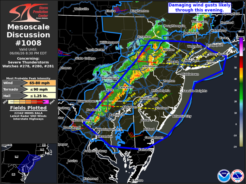
Mesoscale Discussion 1008 NWS Storm Prediction Center Norman OK 0536 PM CDT Sat Jun 06 2026 Areas affected...portions of the Mid Atlantic and Northeast Concerning...Severe Thunderstorm Watch 278...280...281... Valid 062236Z - 070030Z The severe weather threat for Severe Thunderstorm Watch 278, 280, 281 continues. SUMMARY...The threat for damaging wind gusts will continue across the Mid Atlantic and southern New England. Eventually, the line of thunderstorms should begin to weaken as it moves offshore. DISCUSSION...As of 2230 UTC, a well-developed convective line was observed stretching from southern NY State to northern VA. Over the last several hours, this line has produced numerous damaging wind reports over eastern OH, PA and parts of MD. Radar analysis shows a well-established cold pool which should continue to support strong forward propagation of the line this evening. Current projections show the line overspreading the I-95 corridor into western Long Island, Philadelphia and Baltimore over the next 30-90 minutes. Damaging winds remain likely with theses storms. While the storms remain intense, competing influences are apparent farther east toward the coast. Weaker instability and additional marine influences may eventually result in weakening of the line as it approaches and moves offshore this evening. Until then, the threat for damaging gusts remains. ..Lyons.. 06/06/2026 ...Please see www.spc.noaa.gov for graphic product... ATTN...WFO...OKX...PHI...BGM...AKQ...CTP...LWX... LAT...LON 39117748 40837566 41377519 41337406 41287341 41147314 41047292 40957266 40907248 40537262 40197360 39757381 39197419 38767460 38567503 38467525 38437552 38477626 38517656 39117748 MOST PROBABLE PEAK TORNADO INTENSITY...UP TO 90 MPH MOST PROBABLE PEAK WIND GUST...65-80 MPH MOST PROBABLE PEAK HAIL SIZE...UP TO 1.25 IN |
|
|
Top/All Mesoscale Discussions/Forecast Products/Home |
|
Source link