| Mesoscale Discussion 1005 | |
| < Previous MD | |

|
|
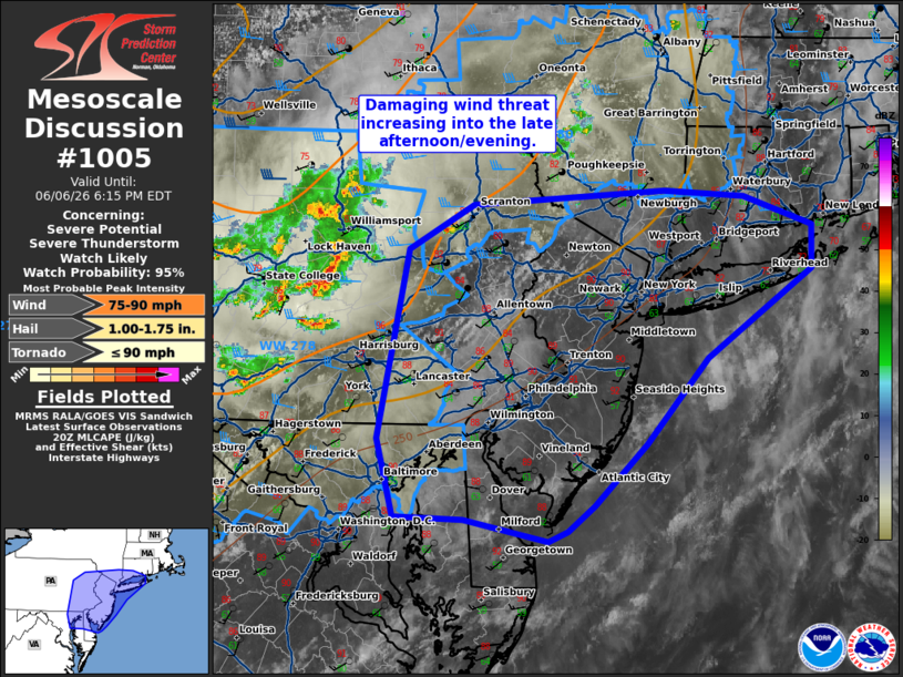
   Mesoscale Discussion 1005
   NWS Storm Prediction Center Norman OK
   0317 PM CDT Sat Jun 06 2026

   Areas affected...western Pennsylvania...New Jersey...New
   York...northern Maryland...Delaware

   Concerning...Severe potential...Severe Thunderstorm Watch likely

   Valid 062017Z - 062215Z

   Probability of Watch Issuance...95 percent

   SUMMARY...Downstream damaging wind potential will increase into the
   late afternoon/evening.

   DISCUSSION...Several clusters of severe storms are advancing
   eastward across PA/WV this afternoon producing gusts 60-70 mph.
   These will likely persist downstream into portions of New Jersey,
   southeast New York, northern Maryland, and Delaware including
   Philadelphia and New York City. The environment downstream is
   characterized by temperatures in the mid 80s to 90s and gradually
   increasing MLCAPE around 1000 J/kg from the west. Steep low level
   lapse rates around 7-8 C/km and the increasingly warm and unstable
   air mass will support maintenance of thunderstorms downstream with
   potential for continued gusts to 70+ mph. A watch will be needed
   soon to cover this potential.

   ..Thornton/Thompson.. 06/06/2026

   ...Please see www.spc.noaa.gov for graphic product...

   ATTN...WFO...OKX...ALY...PHI...BGM...CTP...LWX...

   LAT...LON   41097636 41447570 41547373 41507292 41277221 40927223
               40237329 39577392 39087446 38897472 38817493 38977579
               39007650 39617667 41097636

   MOST PROBABLE PEAK TORNADO INTENSITY...UP TO 90 MPH
   MOST PROBABLE PEAK WIND GUST...75-90 MPH
   MOST PROBABLE PEAK HAIL SIZE...1.00-1.75 IN
|
|
|
Top/All Mesoscale Discussions/Forecast Products/Home |
|
Source link