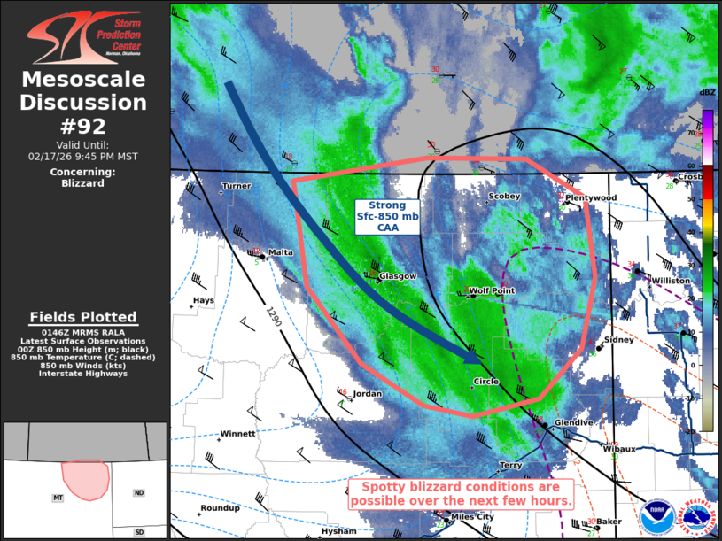
MD 0092 CONCERNING BLIZZARD FOR PORTIONS OF NORTHEASTERN MONTANA
Mesoscale Discussion 0092
NWS Storm Prediction Center Norman OK
0748 PM CST Tue Feb 17 2026

Areas affected...portions of northeastern Montana

Concerning...Blizzard

Valid 180148Z - 180445Z

SUMMARY...At least brief bouts of blizzard conditions are possible
over the next few hours. Winds may sustain over 35 mph periodically,
and overlap with at least moderate snow, potentially resulting in
bouts of reduced visibility.

DISCUSSION...Surface troughing continues to progress eastward across
the northern Plains, supporting very strong surface-850 mb cold-air
advection across portions of northeast Montana. Amid this cold-air
advection is a pronounced band of snow, with at least moderate
snowfall rates likely occurring given the presence of a 1-km deep,
saturated dendritic growth zone per latest mesoanalysis and RAP
forecast soundings. Furthermore, latest mesoanalysis trends also
depict increasing flow in the 925-850 mb layer, perhaps exceeding 50
kts at times. When also considering strong gradient surface flow
already present in the region, any form of downward momentum
transport could support wind fields meeting blizzard criteria, at
least on a spotty basis. These winds may coincide with at least
moderate snowfall rates, leading to reduced visibility.

Potential blizzard conditions are expected to persist for at least
the next 3-4 hours. These conditions may first develop closer to the
Glasgow area and approach the ND border later.

..Squitieri.. 02/18/2026

...Please see www.spc.noaa.gov for graphic product...

ATTN...WFO...GGW...

LAT...LON   48940759 49120609 49110497 48820431 48230422 47700437
            47330485 47190557 47280611 47590680 48160741 48940759
Source link