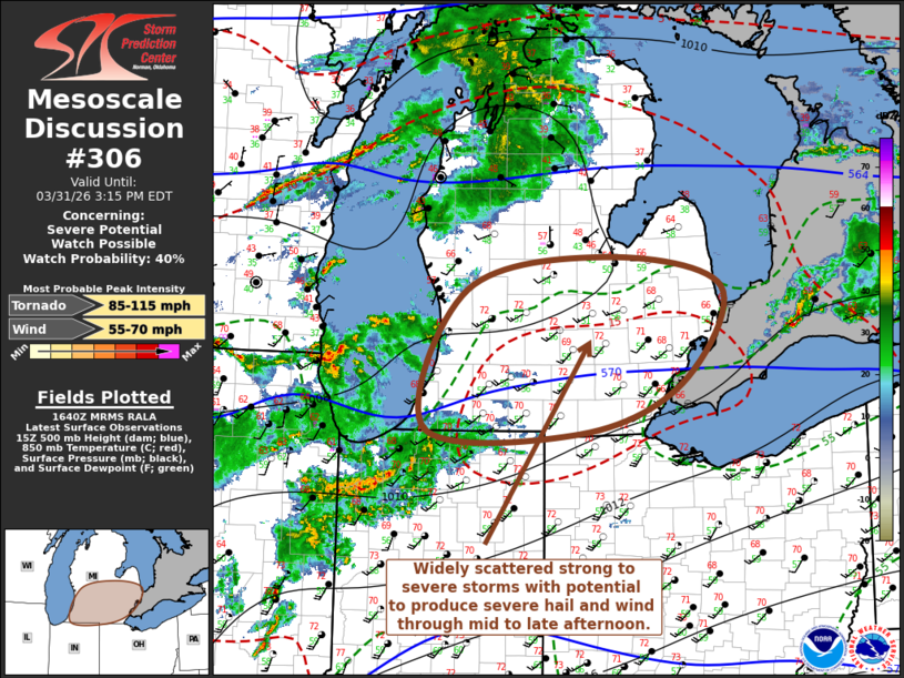
MD 0306 CONCERNING SEVERE POTENTIAL…WATCH POSSIBLE FOR SOUTHERN LOWER MICHIGAN
Mesoscale Discussion 0306
NWS Storm Prediction Center Norman OK
1143 AM CDT Tue Mar 31 2026

Areas affected...southern Lower Michigan

Concerning...Severe potential...Watch possible

Valid 311643Z - 311915Z

Probability of Watch Issuance...40 percent

SUMMARY...Widely scattered strong to severe thunderstorm development
with potential to produce severe hail and wind appears possible by
mid to late afternoon.  It remains unclear whether a severe weather
watch will be needed, but trends are being monitored for this
possibility.

DISCUSSION...A low-amplitude surface frontal wave is in the process
of migrating across central Lower Michigan toward the southern Lake
Huron and adjacent Ontario vicinity this afternoon.  Within its
modestly moist warm sector across southern Lower Michigan,
destabilization is ongoing with insolation, which may yield CAPE up
to around 1000 J/kg within the next few hours, in the presence of
modestly sheared 40+ westerly deep-layer mean flow.

Despite the increasingly conducive environment for strong to severe
thunderstorm development, the potential coverage and evolution of
thunderstorm development remains unclear.  Forcing for ascent
associated with the primary mid-level short wave progressing across
northwestern Ontario appears likely to remain mostly to the cool
side of the frontal zone, while forcing associated with a
low-amplitude short wave to the south remains generally near/south
of the Indiana/Ohio state border vicinity.  However, isolated to
widely scattered strong thunderstorm development with potential to
produce severe hail and wind appears possible for at least period
during the mid to late afternoon hours.

..Kerr/Hart.. 03/31/2026

...Please see www.spc.noaa.gov for graphic product...

ATTN...WFO...DTX...IWX...GRR...

LAT...LON   43498398 43188242 42238296 41728432 41788641 43158585
            43498398

MOST PROBABLE PEAK TORNADO INTENSITY...85-115 MPH
MOST PROBABLE PEAK WIND GUST...55-70 MPH
Source link