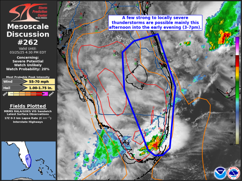
MD 0262 CONCERNING SEVERE POTENTIAL…WATCH UNLIKELY FOR SOUTHEAST FL PENINSULA
Mesoscale Discussion 0262
NWS Storm Prediction Center Norman OK
1255 PM CDT Tue Mar 25 2025

Areas affected...Southeast FL Peninsula

Concerning...Severe potential...Watch unlikely

Valid 251755Z - 252030Z

Probability of Watch Issuance...20 percent

SUMMARY...A few strong to locally severe thunderstorms are possible
mainly this afternoon into the early evening (3-7pm).

DISCUSSION...Water-vapor imagery shows a mid-level vorticity maximum
over the shelf waters to the west of the Everglades/Keys moving east
over the region this afternoon.  Visible-satellite imagery shows a
cumulus field destabilizing from near Lake Okeechobee southward,
where temperatures have warmed into the low-mid 80s with 68-70 deg F
dewpoints.  Modifying the 12 UTC Miami raob for current conditions
yields around 1700 J/kg MLCAPE with minimal CINH.  Although flow in
the lowest 2 km is weak (below 15 kt), westerly flow increasing from
25 kt to 40 kt in the 3-7 km layer, is resulting in a wind profile
that will support some storm organization---mainly in the form of
multicells.

Convection-allowing model guidance (12 UTC HREF and recent
time-lagged HRRR runs) show greater storm coverage beginning in the
3-5pm period.  An initial threat for a stronger storm over the
greater Miami area will gradually expand as storms develop
north/northwest in the vicinity of Lake Okeechobee later this
afternoon.  Relatively cool 500-mb temperatures (-13 to -12 deg C)
will support hail potential with the stronger cells.  Steep
surface-850 mb lapse rates with the more intense water-loaded cores
will also yield a risk for damaging gusts (55-70 mph) with the
stronger storms.  This activity will likely diminish during the
evening as the boundary layer slowly stabilizes and/or storms move
offshore.

..Smith/Hart.. 03/25/2025

...Please see www.spc.noaa.gov for graphic product...

ATTN...WFO...MFL...MLB...KEY...TBW...

LAT...LON   25308043 25408058 26688114 27478119 27708093 27868036
            26747994 25448009 25308025 25308043

MOST PROBABLE PEAK WIND GUST...55-70 MPH
MOST PROBABLE PEAK HAIL SIZE...1.00-1.75 IN
Source link