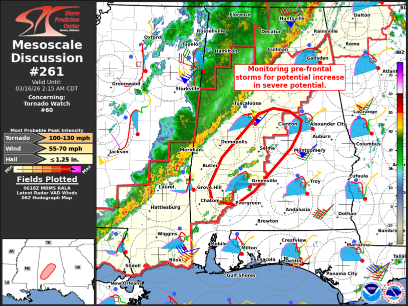
MD 0261 CONCERNING TORNADO WATCH 60… FOR PARTS OF SOUTHWEST AND CENTRAL ALABAMA
Mesoscale Discussion 0261
NWS Storm Prediction Center Norman OK
0121 AM CDT Mon Mar 16 2026

Areas affected...Parts of southwest and central Alabama

Concerning...Tornado Watch 60...

Valid 160621Z - 160715Z

The severe weather threat for Tornado Watch 60 continues.

SUMMARY...A couple storms evolving ahead of the main squall line are
being monitored for a potential increase in severe potential.

DISCUSSION...Ahead of a squall line advancing eastward across
western AL, a couple storms are evolving within a plume of weak
low-level warm advection and surface confluence. While lingering
inhibition (sampled by 04Z BMX sounding) and weak forcing for ascent
cast uncertainty on intensification of these storms -- especially
before being overtaken by the approaching QLCS -- large
clockwise-curved hodographs (around 200-300 m2/s2 effective SRH) and
ample buoyancy will conditionally favor intensification into a
supercell or two. If this were to occur, all severe hazards would be
possible, including tornadoes.

..Weinman.. 03/16/2026

...Please see www.spc.noaa.gov for graphic product...

ATTN...WFO...BMX...MOB...

LAT...LON   31788805 32298778 33078701 33188670 33138636 32958611
            32758614 32478633 31688712 31458751 31528799 31788805

MOST PROBABLE PEAK TORNADO INTENSITY...100-130 MPH
MOST PROBABLE PEAK WIND GUST...55-70 MPH
MOST PROBABLE PEAK HAIL SIZE...UP TO 1.25 IN
Source link