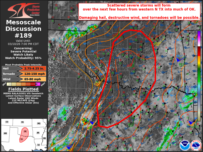
MD 0189 CONCERNING SEVERE POTENTIAL…WATCH LIKELY FOR MUCH OF CENTRAL OKLAHOMA INTO WESTERN NORTH TEXAS
Mesoscale Discussion 0189
NWS Storm Prediction Center Norman OK
0432 PM CDT Tue Mar 10 2026

Areas affected...much of central Oklahoma into western North Texas

Concerning...Severe potential...Watch likely

Valid 102132Z - 110000Z

Probability of Watch Issuance...95 percent

SUMMARY...Scattered severe storms are expected to form over the next
few hours from western North Texas into Oklahoma. Large damaging
hail, destructive winds, and tornadoes will all be possible.

DISCUSSION...Visible satellite imagery across the region clearly
shows an uncapped and unstable air mass from much of OK into TX
along and east of a dryline. Dewpoints have held in the mid to upper
60s, results into over 2500 J/kg MLCAPE. Wind profiles are very
favorable for supercells, with 50 kt effective bulk shear oriented
favorably to the dryline, and, SRH is expected to increase this
evening, enhancing supercell and tornado risk.

Given long hodographs with nearly 100 kt in the upper levels, steep
lapse rates and ample moisture, very large destructive hail will be
possible.  A strong tornado may occur as well especially this
evening and before convective merges into a possible severe MCS.

..Jewell/Hart.. 03/10/2026

...Please see www.spc.noaa.gov for graphic product...

ATTN...WFO...TSA...FWD...OUN...SJT...

LAT...LON   33009933 34159887 35299862 36019845 36489784 36589748
            36509687 36009628 35309608 34209610 33319668 32639748
            32239820 32049874 32119920 33009933

MOST PROBABLE PEAK TORNADO INTENSITY...120-150 MPH
MOST PROBABLE PEAK WIND GUST...65-80 MPH
MOST PROBABLE PEAK HAIL SIZE...2.75-4.25 IN
Source link